Fort Sheridan
Current Weather
Overcast Clouds
Feels like: 22.3°C (72.1°F)
Sun Schedule
⚠️ Live forecasts now on mobile app only
This page is showing cached weather data. For real-time forecasts and updates for all cities, please download our mobile app:
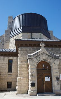
City Images

Fort Sheridan - Photo 1
Photo by Valentina Rodriguez

Fort Sheridan - Photo 2
Photo by Sergio Arteaga
Fort Sheridan - Photo 3
Photo by Tom Kowalsky
Fort Sheridan, United States
Click any image to view larger versionPast Weather Alerts
5 of 67Wind Advisory
* WHAT...West winds 25 to 35 mph with gusts up to 45 mph. * WHERE...Portions of north central and n...
Wind Advisory
* WHAT...West winds 20 to 30 mph with gusts up to 45 mph expected. * WHERE...Portions of north cent...
Wind Advisory
* WHAT...West winds 25 to 35 mph with gusts up to 45 mph. * WHERE...Livingston, Ford, Iroquois, La ...
Wind Advisory
* WHAT...West winds 20 to 30 mph with gusts up to 45 mph expected. * WHERE...Livingston, Ford, Iroq...
Wind Advisory
* WHAT...West winds 20 to 30 mph with gusts up to 45 mph expected. * WHERE...Portions of north cent...
Past Weather Alerts for Fort Sheridan
Wind Advisory
* WHAT...West winds 25 to 35 mph with gusts up to 45 mph. * WHERE...Portions of north central and northeast Illinois and northwest Indiana. * WHEN...Until 4 PM CST /5 PM EST/ this afternoon. * IMPACTS...Gusty winds will blow around unsecured objects. Tree limbs could be blown down and a few power outages may result.
Wind Advisory
* WHAT...West winds 20 to 30 mph with gusts up to 45 mph expected. * WHERE...Portions of north central and northeast Illinois and northwest Indiana. * WHEN...From 6 AM CST /7 AM EST/ to 4 PM CST /5 PM EST/ Friday. * IMPACTS...Gusty winds will blow around unsecured objects. Tree limbs could be blown down and a few power outages may result.
Wind Advisory
* WHAT...West winds 25 to 35 mph with gusts up to 45 mph. * WHERE...Livingston, Ford, Iroquois, La Salle, Eastern Will, Grundy, Kankakee, Kendall, Northern Will, Southern Cook, and Southern Will Counties. * WHEN...Until 4 PM CST this afternoon. * IMPACTS...Gusty winds will blow around unsecured objects. Tree limbs could be blown down and a few power outages may result.
Wind Advisory
* WHAT...West winds 20 to 30 mph with gusts up to 45 mph expected. * WHERE...Livingston, Ford, Iroquois, La Salle, Eastern Will, Grundy, Kankakee, Kendall, Northern Will, Southern Cook, and Southern Will Counties. * WHEN...Until 4 PM CST this afternoon. * IMPACTS...Gusty winds will blow around unsecured objects. Tree limbs could be blown down and a few power outages may result.
Wind Advisory
* WHAT...West winds 20 to 30 mph with gusts up to 45 mph expected. * WHERE...Portions of north central and northeast Illinois and northwest Indiana. * WHEN...Until 4 PM CST /5 PM EST/ this afternoon. * IMPACTS...Gusty winds will blow around unsecured objects. Tree limbs could be blown down and a few power outages may result.
Wind Advisory
* WHAT...Northwest winds 20 to 30 mph with gusts up to 45 mph expected. * WHERE...Portions of south central and southeast Wisconsin. * WHEN...From 6 AM to 3 PM CST Friday. * IMPACTS...Gusty winds will blow around unsecured objects. Tree limbs could be blown down and a few power outages may result. * ADDITIONAL DETAILS...The highest wind gusts (around 45 mph) may only last a few hours of this time window in any given area, but when combined with the snowfall (particularly in the western half of the advisory area), could further worsen travel conditions and increase strain on tree branches.
Special Weather Statement
ELEVATED FIRE WEATHER CONDITIONS EXPECTED FOR MUCH OF SOUTHERN WI... Clearing skies during the day Wednesday will lead to strong mixing and thus relative humidities are expected to plummet to 15-25% with very breezy winds (gusts to 40mph). This will lead to an increased concern for fire weather.
Special Weather Statement
The combination of unseasonably warm temperatures, low relative humidity and gusty westerly winds will lead to a heightened threat of brush fire ignition and spread this afternoon. Any fires that ignite may become difficult to control. Outdoor burning is strongly discouraged.
Red Flag Warning
The National Weather Service in Chicago has issued a Red Flag Warning, which is in effect from 10 AM this morning to 8 PM CST this evening. This replaces the Fire Weather Watch that was previously in effect. * Affected Area...Winnebago, Boone, McHenry, Ogle, Lee, De Kalb, Kane, La Salle, Kendall and Grundy. * Timing...From 10 AM this morning to 8 PM CST this evening. * Winds...West 20 to 30 mph with gusts up to 40 to 45 mph. * Relative Humidity...As low as 15 to 20 percent. * Impacts...Any fire that develops will catch and spread quickly. Outdoor burning is not recommended.
Fire Weather Watch
...A FIRE WEATHER WATCH IS IN EFFECT FOR WEDNESDAY... The combination of unseasonably warm temperatures (highs in the 60s), dry conditions (RH values around 15-25%), and gusty west- southwest winds (gusting around 35-40 mph) will lead to an elevated fire danger on Wednesday. While fuel moistures may be more questionable in some areas, local fire agencies indicate that finer fuels are primed and could lead to rapid fire spread in these conditions. For this reason, a Fire Weather Watch has been issued for portions of northern Illinois on Wednesday. Confidence in Red Flag Warning criteria being met is currently highest along and north of Interstate 88. * Affected Area...Winnebago, Boone, McHenry, Lake IL, Ogle, Lee, De Kalb, Kane, DuPage, Cook, La Salle, Kendall, Grundy and Will. * Timing...From 9 AM CST Wednesday through Wednesday evening. * Winds...Southwest 15 to 25 mph with gusts up to 40 to 45 mph. * Relative Humidity...As low as 15 percent. * Impacts...Any fire that develops will catch and spread quickly. Outdoor burning is not recommended.
Fire Weather Watch
...A FIRE WEATHER WATCH IS IN EFFECT FOR WEDNESDAY... The combination of unseasonably warm temperatures (highs in the 60s), dry conditions (RH values around 15-25%), and gusty west- southwest winds (gusting around 35-40 mph) will lead to an elevated fire danger on Wednesday. While fuel moistures may be more questionable in some areas, local fire agencies indicate that finer fuels are primed and could lead to rapid fire spread in these conditions. For this reason, a Fire Weather Watch has been issued for portions of northern Illinois on Wednesday. Confidence in Red Flag Warning criteria being met is currently highest along and north of Interstate 88. The National Weather Service in Chicago has issued a Fire Weather Watch, which is in effect from Wednesday morning through Wednesday evening. * Affected Area...Winnebago, Boone, McHenry, Lake IL, Ogle, Lee, De Kalb, Kane, DuPage, Cook, La Salle, Kendall, Grundy and Will. * Timing...From Wednesday morning through Wednesday evening. * Winds...Southwest 15 to 25 mph with gusts up to 40 mph. * Relative Humidity...As low as 15 percent. * Impacts...Any fire that develops will catch and spread quickly. Outdoor burning is not recommended.
Winter Weather Advisory
* WHAT...Lake effect snow expected. Additional snow accumulations between 2 and 4 inches along the Cook County shore to 1 inch or less along and west of the Interstate 294 corridor. Localized totals over 4 inches possible along the shore. * WHERE...Central Cook, Northern Cook, and Southern Cook Counties. * WHEN...Until 4 PM CST this afternoon. * IMPACTS...Roads, and especially bridges and overpasses, will likely become slick and hazardous. * ADDITIONAL DETAILS...A main lake effect snow band is expected to move over the area prior to sunrise, then settle along the Cook County shore, including downtown Chicago, through the day. Though the intensity of snow will gradually diminish through the day, localized snowfall rates over 1 inch per hour are expected this morning.
Winter Weather Advisory
* WHAT...Lake effect snow expected Saturday morning. Total snow accumulations could locally exceed 3 inches, especially near the lake. * WHERE...Northern Cook County. * WHEN...From 6 AM to 4 PM CST Saturday. * IMPACTS...Roads, and especially bridges and overpasses, will likely become slick and hazardous. * ADDITIONAL DETAILS...The band of snow is expected to shift back westward into parts of northeastern Illinois Saturday morning. This will likely result in additional localized accumulations and travel impacts.
Winter Weather Advisory
* WHAT...Lake effect snow expected Saturday morning. Total snow accumulations could locally exceed 3 inches, especially near the lake. * WHERE...Central Cook and Southern Cook Counties. * WHEN...From 6 AM to 4 PM CST Saturday. * IMPACTS...Localized hazardous travel is expected on Saturday especially near the lake. * ADDITIONAL DETAILS...A band of lake effect snow is expected to shift back westward Saturday morning, and is expected to impact parts of northeastern Illinois on Saturday. While the footprint of accumulating snow is likely to be lower, localized additional accumulations and associated travel impacts are expected.
Winter Storm Warning
* WHAT...For the Winter Storm Warning, heavy lake effect snow. Snow accumulations locally in excess of 6 inches, particularly in areas near the lake. For the Winter Storm Watch, heavy lake effect snow possible, with additional accumulations possible into Saturday morning. * WHERE...Central Cook and Southern Cook Counties. * WHEN...For the Winter Storm Warning, until midnight CST tonight. For the Winter Storm Watch, from late tonight through Saturday morning. * IMPACTS...Travel could be very difficult at times, with near white out conditions and snowfall rates of 1 to 2 inches per hour under the most intense portions of the band through this evening. * ADDITIONAL DETAILS...A burst of accumulating snow is expected through early afternoon, with rates of 1 to 2 inches per hour at times. This will make for hazardous travel conditions. While a short break in the heavy snow is possible for a period this afternoon, a second round of intense lake effect snow is expected to bring at least a few hour period of snowfall rates up to 2 inches per hour this evening. Finally, the lake effect snow band may shift back westward along the state line and bring another period of heavy lake effect snow for several hours Saturday morning.
Winter Storm Watch
* WHAT...For the Winter Storm Warning, heavy lake effect snow. Snow accumulations locally in excess of 6 inches, particularly in areas near the lake. For the Winter Storm Watch, heavy lake effect snow possible, with additional accumulations possible into Saturday morning. * WHERE...Central Cook and Southern Cook Counties. * WHEN...For the Winter Storm Warning, until midnight CST tonight. For the Winter Storm Watch, from late tonight through Saturday morning. * IMPACTS...Travel could be very difficult at times, with near white out conditions and snowfall rates of 1 to 2 inches per hour under the most intense portions of the band through this evening. * ADDITIONAL DETAILS...A burst of accumulating snow is expected through early afternoon, with rates of 1 to 2 inches per hour at times. This will make for hazardous travel conditions. While a short break in the heavy snow is possible for a period this afternoon, a second round of intense lake effect snow is expected to bring at least a few hour period of snowfall rates up to 2 inches per hour this evening. Finally, the lake effect snow band may shift back westward along the state line and bring another period of heavy lake effect snow for several hours Saturday morning.
Winter Weather Advisory
* WHAT...Snow expected, possibly falling heavily at times. A quick 1 to 3 inches of accumulation is expected within just a 2 or 3 hour period. Locally higher amounts possible with lake-enhanced snow over Lake and northern Cook Counties. * WHERE...DuPage, Lake IL, and Northern Cook Counties. * WHEN...Until 6 PM CST this evening. * IMPACTS...Roads, bridges and overpasses will likely become slick and hazardous. Plan on slippery road conditions. The hazardous conditions could impact the evening commute. * ADDITIONAL DETAILS...A burst of accumulating snow is expected into this afternoon. The snow during this period may briefly fall at a rate of up to an inch per hour and make for slick travel conditions.
Special Weather Statement
A lake-effect snow band has moved onshore over Milwaukee County and will move south-southwest into eastern Waukesha, Racine, and Kenosha Counties. Expect a burst of heavy snow, quick accumulations on roadways, and rapid reductions in visibility when traveling into this snow band. Reduce speed and leave extra time for travel.
Winter Storm Watch
* WHAT...For the Winter Weather Advisory, periods of snow expected through the day. A quick 1 to 3 inches of accumulation is expected within a few hour period this morning. For the Winter Storm Watch, heavy lake effect snow possible, first over a short period this evening, then again late tonight through Saturday morning. Snow accumulations of 6 or more inches are possible, mainly east of the Dan Ryan and I-57. * WHERE...Central Cook and Southern Cook Counties. * WHEN...For the Winter Weather Advisory, from 9 AM this morning to 6 PM CST this evening. For the Winter Storm Watch, from this evening through Saturday morning. * IMPACTS...Travel will likely become hazardous as roads become snow covered during the mid to late morning and again this evening, possibly affecting the evening commute. * ADDITIONAL DETAILS...A burst of accumulating snow is expected mid to late morning and may briefly fall at a rate of up to an inch per hour, making for hazardous travel conditions. A second round of lake effect snow will bring a brief period of snowfall rates up to 2 inches per hour early to mid-evening. Finally, a lake effect snow band may shift westward along the state line and bring a period of heavy lake effect snow for several hours Saturday morning.
Winter Weather Advisory
* WHAT...Snow expected, possibly falling heavily at times. A quick 1 to 3 inches of accumulation is expected within just a 2 or 3 hour period. Locally higher amounts possible with lake-enhanced snow over Lake County. * WHERE...DuPage, Lake IL, and Northern Cook Counties. * WHEN...From 9 AM this morning to 6 PM CST this evening. * IMPACTS...Roads, bridges and overpasses will likely become slick and hazardous. Plan on slippery road conditions. The hazardous conditions could impact the evening commute.
Winter Weather Advisory
* WHAT...Lake effect snow. Total snow accumulations between 1 and 6 inches, lowest totals over western portions of Lake County and northwest Cook County. Isolated totals over 6 inches possible within a few miles of the lakeshore. * WHERE...Central Cook, Lake IL, and Northern Cook Counties. * WHEN...Until 6 PM CST this evening. * IMPACTS...Roads, and especially bridges and overpasses, will likely become slick and hazardous.
Winter Weather Advisory
* WHAT...Snow. Total snow accumulations between 2 and 5 inches, highest east of Interstate 55 and south of Interstate 80. * WHERE...Portions of central, east central, north central, and northeast Illinois. * WHEN...Until 6 PM CST this evening. * IMPACTS...Roads, and especially bridges and overpasses, will likely become slick and hazardous.
Cold Weather Advisory
* WHAT...Very cold wind chills around 20 below expected. * WHERE...Central Cook County. * WHEN...From midnight tonight to noon CST Monday. * IMPACTS...The dangerously cold wind chills as low as 20 below zero could cause frostbite on exposed skin in as little as 30 minutes.
Cold Weather Advisory
* WHAT...Very cold wind chills as low as 20 to 25 below expected. * WHERE...Portions of central, east central, north central, and northeast Illinois. * WHEN...From midnight tonight to noon CST Monday. * IMPACTS...The dangerously cold wind chills as low as 25 below zero could cause frostbite on exposed skin in as little as 30 minutes.
Winter Weather Advisory
* WHAT...Lake effect snow. Total snow accumulations between 2 to 4 inches over far southeast Milwaukee County and far eastern Racine County. Locally higher totals possible along the immediate Lake Michigan shoreline. * WHERE...Milwaukee and Racine Counties. * WHEN...Until 3 PM CST this afternoon. * IMPACTS...Plan on slippery road conditions.
Cold Weather Advisory
* WHAT...Very cold wind chills as low as 26 below expected. * WHERE...Portions of east central, south central, and southeast Wisconsin. * WHEN...From midnight tonight to noon CST Monday. * IMPACTS...The dangerously cold wind chills as low as 26 below zero could cause frostbite on exposed skin in as little as 30 minutes.
Winter Weather Advisory
* WHAT...Lake effect snow expected. Total snow accumulations of 2 to 4 inches over far eastern Kenosha County. Locally higher totals possible along the immediate Lake Michigan shoreline. * WHERE...Kenosha County. * WHEN...Until 3 PM CST this afternoon. * IMPACTS...Plan on slippery road conditions.
Winter Weather Advisory
* WHAT...Hazardous travel conditions due to snow occurring. * WHERE...Central Cook, Lake IL, and Northern Cook Counties. * WHEN...Until 6 PM CST Sunday. * IMPACTS...Roads, bridges, and overpasses, will be slick and hazardous. Visibility may occasionally drop below 1 mile, particularly during the day on Sunday. * ADDITIONAL DETAILS...Steady snow overnight will transition into localized lake effect snow by daybreak Sunday. As a result, total snow accumulations will vary across the impacted counties with around an inch near and west of Interstate 94/294, and localized totals up to 6 inches along the immediate Lake Michigan shoreline.
Winter Weather Advisory
* WHAT...Hazardous travel conditions due to snow occurring. * WHERE...Portions of central, east central, north central, and northeast Illinois. * WHEN...Until 6 PM CST Sunday. * IMPACTS...Roads, bridges, and overpasses, will be slick and hazardous. * ADDITIONAL DETAILS...Total snow accumulations will range from around an inch or two near the Interstate 88 and 80 corridors to 4 to 7 inches near US 10.
Winter Weather Advisory
* WHAT...Lake effect snow expected. Total snow accumulations of 2 to 4 inches over far eastern Kenosha County. * WHERE...Kenosha County. * WHEN...From 6 AM to 3 PM CST Sunday. * IMPACTS...Plan on slippery road conditions.
Winter Weather Advisory
* WHAT...Lake effect snow expected. Total snow accumulations of 2 to 5 inches over far eastern Racine County. * WHERE...Racine County. * WHEN...From 1 AM to 3 PM CST Sunday. * IMPACTS...Plan on slippery road conditions.
Winter Weather Advisory
* WHAT...Snow expected. Total snow accumulations between 2 and 5 inches, highest east of Interstate 55. Lower snow totals are forecasted across northwestern portions of La Salle, Kendall, and DuPage counties. * WHERE...Portions of central, north central, and northeast Illinois. * WHEN...From 6 PM this evening to 6 PM CST Sunday. * IMPACTS...Roads, and especially bridges and overpasses, will likely become slick and hazardous.
Winter Weather Advisory
* WHAT...Snow expected. Total snow accumulations between 2 and 6 inches, highest within a few miles of the lakeshore. Lower snow totals are forecasted across western portions of Lake and northern Cook counties. * WHERE...Central Cook, Lake IL, and Northern Cook Counties. * WHEN...From 6 PM this evening to 6 PM CST Sunday. * IMPACTS...Roads, and especially bridges and overpasses, will likely become slick and hazardous.
Hydrologic Outlook
ESFLOT Cold temperatures this week have caused a significant increase in river ice across the area, including multiple ice jams. Cold temperatures are expected to continue into next week, with favorable conditions for river ice formation. Areas of open river may see new ice growth, while areas with existing ice cover my thicken. No widespread flooding is expected, but ice jams will be possible in isolated areas, especially along the Rock, Fox, and Kankakee rivers. Ice jams may cause rises or fluctuations on area rivers with little warning. Persons with interests along area rivers should closely monitor the latest forecasts.
Cold Weather Advisory
* WHAT...Very cold wind chills as low as 30 below. * WHERE...Portions of south central and southeast Wisconsin. * WHEN...Until noon CST today. * IMPACTS...The dangerously cold wind chills as low as 30 below zero could cause frostbite on exposed skin in as little as 30 minutes.
Cold Weather Advisory
* WHAT...Very cold wind chills as low as 25 to 30 below this morning. * WHERE...Portions of central, north central, and northeast Illinois. * WHEN...Until noon CST today. * IMPACTS...The dangerously cold wind chills as low as 25 to 30 below zero could cause frostbite on exposed skin in as little as 30 minutes.
Cold Weather Advisory
* WHAT...Very cold wind chills as low as 20 to 30 below this morning. * WHERE...Central Cook County. * WHEN...Until noon CST today. * IMPACTS...The dangerously cold wind chills as low as 30 below zero could cause frostbite on exposed skin in as little as 10 to 30 minutes.
Cold Weather Advisory
* WHAT...Very cold wind chills as low as 25 to 30 below. * WHERE...Portions of central, north central, and northeast Illinois. * WHEN...Until 9 AM CST Saturday. * IMPACTS...The dangerously cold wind chills as low as 25 to 30 below zero could cause frostbite on exposed skin in as little as 30 minutes.
Cold Weather Advisory
* WHAT...Very cold wind chills as low as 15 to 30 below expected. * WHERE...Central Cook County. * WHEN...Until 9 AM CST Saturday. * IMPACTS...The dangerously cold wind chills as low as 30 below zero could cause frostbite on exposed skin in as little as 10 to 30 minutes.
Cold Weather Advisory
* WHAT...Very cold wind chills as low as 31 below. * WHERE...Portions of south central and southeast Wisconsin. * WHEN...Until noon CST Saturday. * IMPACTS...The dangerously cold wind chills as low as 30 below zero could cause frostbite on exposed skin in as little as 10 minutes.
Cold Weather Advisory
* WHAT...Very cold wind chills as low as 25 below. * WHERE...Central Cook County. * WHEN...Until 9 AM CST Saturday. * IMPACTS...The dangerously cold wind chills as low as 25 below zero could cause frostbite on exposed skin in as little as 30 minutes.