Lake Geneva
Current Weather
Broken Clouds
Feels like: 25.8°C (78.4°F)
Sun Schedule
⚠️ Live forecasts now on mobile app only
This page is showing cached weather data. For real-time forecasts and updates for all cities, please download our mobile app:
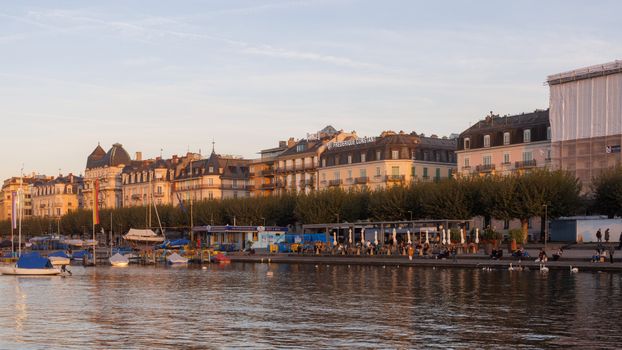
City Images
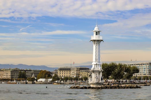
Lake Geneva - Photo 1
Photo by Martín Álvarez Mullally

Lake Geneva - Photo 2
Photo by Christopher Politano
Lake Geneva - Photo 3
Photo by Marcelo Borelli
Lake Geneva, United States
Click any image to view larger versionPast Weather Alerts
5 of 63Flood Warning
...The Flood Warning is extended for the following rivers in Illinois... Kishwaukee River near Perr...
Flood Warning
* WHAT...Flooding caused by excessive rainfall continues. * WHERE...A portion of northeast Illinois...
Flood Warning
...The Flood Warning continues for the following rivers in Illinois... Fox River at Montgomery affe...
Flood Warning
...The Flood Warning continues for the following rivers in Wisconsin...Illinois... Fox River Lower ...
Flood Warning
...The Flood Warning is extended for the following rivers in Wisconsin... Crawfish River At Milford...
Past Weather Alerts for Lake Geneva
Flood Warning
...The Flood Warning is extended for the following rivers in Illinois... Kishwaukee River near Perryville affecting Winnebago County. For the Kishwaukee River...including Perryville...Minor flooding is forecast. * WHAT...Minor flooding is occurring and minor flooding is forecast. * WHERE...Kishwaukee River from Confluence with South Branch Kishwaukee River downstream to the Rock River, including the Perryville gauge. * WHEN...Until tomorrow afternoon. * IMPACTS...At 13.0 feet, Roadways threatened at Blackhawk Valley Campground south of Rockford. * ADDITIONAL DETAILS... - At 8:30 PM CDT Friday the stage was 13.1 feet. - Forecast...The river is cresting and will fall below flood stage Saturday afternoon. - Flood stage is 12.0 feet. - http://www.weather.gov/safety/flood
Flood Warning
* WHAT...Flooding caused by excessive rainfall continues. * WHERE...A portion of northeast Illinois, including the following counties, Lake IL and McHenry. * WHEN...Until further notice. * IMPACTS...Numerous roads, yards, structures, and areas of park land are flooding along the Fox River Chain of Lakes. Flooding will continue through at least next week. * ADDITIONAL DETAILS... - At 138 PM CDT, River gauges along the Fox River Chain of Lakes indicate that water levels have remained nearly steady for the past 24 hours and are likely at a crest in major flood stage. The latest forecast from the Illinois Department of Natural Resources indicates that water levels should begin to slowly fall by Friday. - Some locations that will experience flooding include areas along the Fox River Chain of Lakes, including Nippersink Lake, Fox Lake, Pistakee Lake, Petite Lake, Lake Marie, Channel Lake, and Lake Catherine. - http://www.weather.gov/safety/flood
Flood Warning
...The Flood Warning continues for the following rivers in Illinois... Fox River at Montgomery affecting Kendall and Kane Counties. Fox River at Algonquin Lock & Dam tailwater affecting McHenry, Kane and Lake IL Counties. * WHAT...Major flooding is occurring and is forecasted to continue. * WHERE...Fox River from Johnsburg downstream to Red Gate Road in St. Charles, including the Algonquin Lock & Dam tailwater gauge. * WHEN...Until further notice. * IMPACTS...At 12.0 feet, structures threatened along River Street, Johnson Street, and Maiden Lane in East Dundee. North Harrison Street threatened near Riverside Park in Algonquin. Washington Street threatened in Carpentersville. Water Street, Edwards Avenue, and Elgin Avenue threatened in East Dundee. Bayview Road threatened in Elgin. Low-lying areas of Festival Park are threatened in Elgin. * ADDITIONAL DETAILS... - At 8:30 PM CDT Thursday, the stage was 12.0 feet. - Forecast...The river is expected to remain nearly steady around its crest of 12.0 feet through Friday. It will then begin a very slow fall but will remain above flood stage through at least next week. - Flood stage is 9.5 feet. - http://www.weather.gov/safety/flood
Flood Warning
...The Flood Warning continues for the following rivers in Wisconsin...Illinois... Fox River Lower Near New Munster affecting Kenosha and Lake Counties. * WHAT...Moderate flooding is occurring and moderate flooding is forecast. * WHERE...Fox River Lower near New Munster. * WHEN...Until further notice. * IMPACTS...At 14.0 feet, There is flooding of the lower levels of homes in the Town of Wheatland and Village of Salem Lakes areas long Riverside Drive, Shorewood Drive, 101st Street and Shorewood Terrace. * ADDITIONAL DETAILS... - At 9:00 PM CDT Thursday the stage was 13.8 feet. - Bankfull stage is 10.0 feet. - Recent Activity...The maximum river stage in the 24 hours ending at 9:00 PM CDT Thursday was 14.1 feet. - Forecast...The river is expected to gradually fall through the weekend and go below moderate flood on Saturday. - Flood stage is 11.0 feet. - Flood History...This crest compares to a previous crest of 13.7 feet on 05/24/2004. - http://www.weather.gov/safety/flood
Flood Warning
...The Flood Warning is extended for the following rivers in Wisconsin... Crawfish River At Milford affecting Jefferson County. ...The Flood Warning continues for the following rivers in Wisconsin...Illinois... Rock River At Newville affecting Rock County. Rock River Near Lake Koshkonong affecting Rock and Jefferson Counties. Rock River At Fort Atkinson affecting Jefferson County. Rock River At Afton affecting Rock and Winnebago Counties. Rock River At Jefferson affecting Jefferson County. Rock River At Watertown affecting Jefferson County. ROCK RIVER near LEBANON-3 E-HWY MM BRIDGE affecting Dodge County. Fox River At Princeton affecting Green Lake County. Fox River Near Berlin affecting Green Lake County. Fox River Lower Near New Munster affecting Lake and Kenosha Counties. ...The Flood Warning is cancelled for the following rivers in Wisconsin... Fox River Lower At Rochester affecting Racine County. * WHAT...Moderate flooding is occurring and moderate flooding is forecast. * WHERE...Fox River Lower near New Munster. * WHEN...Until further notice. * IMPACTS...At 14.0 feet, There is flooding of the lower levels of homes in the Town of Wheatland and Village of Salem Lakes areas long Riverside Drive, Shorewood Drive, 101st Street and Shorewood Terrace. * ADDITIONAL DETAILS... - At 5:00 PM CDT Thursday the stage was 13.9 feet. - Bankfull stage is 10.0 feet. - Recent Activity...The maximum river stage in the 24 hours ending at 5:00 PM CDT Thursday was 14.2 feet. - Forecast...The river is expected to fall to 11.5 feet Thursday, April 30. - Flood stage is 11.0 feet. - Flood History...This crest compares to a previous crest of 13.7 feet on 05/24/2004. - http://www.weather.gov/safety/flood
Flood Warning
...The Flood Warning continues for the following rivers in Illinois... Fox River at Montgomery affecting Kane and Kendall Counties. Fox River at Algonquin Lock & Dam tailwater affecting Kane, McHenry and Lake IL Counties. * WHAT...Major flooding is occurring and major flooding is forecast. * WHERE...Fox River from Johnsburg downstream to Red Gate Road in St. Charles, including the Algonquin Lock & Dam tailwater gauge. * WHEN...Until further notice. * IMPACTS...At 12.0 feet, Structures threatened along River Street, Johnson Street, and Maiden Lane in East Dundee. North Harrison Street threatened near Riverside Park in Algonquin. Washington Street threatened in Carpentersville. Water Street, Edwards Avenue, and Elgin Avenue threatened in East Dundee. Bayview Road threatened in Elgin. Low-lying areas of Festival Park are threatened in Elgin. * ADDITIONAL DETAILS... - At 9:30 AM CDT Thursday the stage was 12.0 feet. - Forecast...The river is expected to crest around 12.0 to 12.1 feet this afternoon through Friday, then begin a very slow fall but remain above flood stage through next week. - Flood stage is 9.5 feet. - http://www.weather.gov/safety/flood
Dense Fog Advisory
* WHAT...Visibility one quarter mile or less in dense fog. * WHERE...Kenosha, Milwaukee, and Racine Counties. * WHEN...Until 6 AM CST Friday. * IMPACTS...Low visibility could make driving conditions hazardous.
Dense Fog Advisory
* WHAT...Visibility less than one mile in dense fog. * WHERE...Green, Lafayette, Rock, Kenosha, Racine, and Walworth Counties. * WHEN...Until noon CST today. * IMPACTS...Low visibility could make driving conditions hazardous. * ADDITIONAL DETAILS...The dense fog may shift further northward into this morning.
Dense Fog Advisory
* WHAT...Visibility of one quarter mile or less in dense fog expected. * WHERE...In Illinois, Central Cook, DuPage, Lake IL, Northern Cook, and Southern Cook Counties. In Indiana, Lake IN and Porter Counties. * WHEN...Until 3 PM CST this afternoon. * IMPACTS...Low visibility could make driving conditions hazardous.
Dense Fog Advisory
* WHAT...Visibility of one quarter mile or less in dense fog expected. * WHERE...De Kalb, La Salle, Eastern Will, Grundy, Kane, Kankakee, Kendall, McHenry, Northern Will, and Southern Will Counties. * WHEN...Until noon CST today. * IMPACTS...Low visibility could make driving conditions hazardous.
Dense Fog Advisory
* WHAT...Visibility of one quarter mile or less in dense fog expected. * WHERE...Boone, Lee, Ogle, and Winnebago Counties. * WHEN...Until noon CST today. * IMPACTS...Low visibility could make driving conditions hazardous.
Winter Weather Advisory
* WHAT...Snow. Additional snow accumulations up to one inch. * WHERE...A portion of southeast Wisconsin. * WHEN...Until 8 PM CST this evening. * IMPACTS...Plan on slippery road conditions.
Wind Advisory
* WHAT...West winds 25 to 35 mph with gusts up to 45 mph. * WHERE...Portions of north central and northeast Illinois and northwest Indiana. * WHEN...Until 4 PM CST /5 PM EST/ this afternoon. * IMPACTS...Gusty winds will blow around unsecured objects. Tree limbs could be blown down and a few power outages may result.
Special Weather Statement
ELEVATED FIRE WEATHER CONDITIONS EXPECTED FOR MUCH OF SOUTHERN WI... Clearing skies during the day Wednesday will lead to strong mixing and thus relative humidities are expected to plummet to 15-25% with very breezy winds (gusts to 40mph). This will lead to an increased concern for fire weather.
Wind Advisory
* WHAT...West winds 20 to 30 mph with gusts up to 45 mph expected. * WHERE...Boone, De Kalb, Lee, Central Cook, DuPage, Kane, Lake IL, McHenry, and Northern Cook Counties. * WHEN...Until 6 PM CST this evening. * IMPACTS...Gusty winds will blow around unsecured objects. Tree limbs could be blown down and a few power outages may result.
Wind Advisory
* WHAT...West winds 20 to 30 mph with gusts up to 50 mph expected. * WHERE...Ogle and Winnebago Counties. * WHEN...Until 6 PM CST this evening. * IMPACTS...Gusty winds will blow around unsecured objects. Tree limbs could be blown down and a few power outages may result.
Red Flag Warning
...RED FLAG WARNING EXPANDED TO INCLUDE CHICAGO METRO... Conditions will turn very dry and windy this afternoon, making conditions supportive of brush fire spread. Even with rainfall last night generally 0.05 to 0.15 of an inch across northeastern Illinois, the combination of warm, dry, and windy conditions will cause fine fuels to dry out by early afternoon. As a result, the Red Flag Warning was expanded to include Cook, DuPage, Will, Kankakee, and Lake (IL) Counties until 8 PM this evening. The National Weather Service in Chicago has issued a Red Flag Warning, which is in effect until 8 PM CST this evening. * Affected Area...Lake IL, DuPage, Cook, Will and Kankakee. * Timing...Until 8 PM CST this evening. * Winds...Southwest 20 to 30 mph with gusts up to 45 mph. * Relative Humidity...As low as 15 to 20 percent. * Impacts...Any fire that develops will catch and spread quickly. Outdoor burning is not recommended.
Red Flag Warning
...RED FLAG WARNING EXPANDED TO INCLUDE CHICAGO METRO... Conditions will turn very dry and windy this afternoon, making conditions supportive of brush fire spread. Even with rainfall last night generally 0.05 to 0.15 of an inch across northeastern Illinois, the combination of warm, dry, and windy conditions will cause fine fuels to dry out by early afternoon. As a result, the Red Flag Warning was expanded to include Cook, DuPage, Will, Kankakee, and Lake (IL) Counties until 8 PM this evening. * Affected Area...Winnebago, Boone, McHenry, Ogle, Lee, De Kalb, Kane, La Salle, Kendall, Grundy and Livingston. * Timing...Until 8 PM CST this evening. * Winds...Southwest 20 to 30 mph with gusts up to 50 mph. * Relative Humidity...As low as 15 to 20 percent. * Impacts...Any fire that develops will catch and spread quickly. Outdoor burning is not recommended.
Winter Weather Advisory
* WHAT...Hazardous travel conditions due to snow occurring. * WHERE...Central Cook, Lake IL, and Northern Cook Counties. * WHEN...Until 6 PM CST Sunday. * IMPACTS...Roads, bridges, and overpasses, will be slick and hazardous. Visibility may occasionally drop below 1 mile, particularly during the day on Sunday. * ADDITIONAL DETAILS...Steady snow overnight will transition into localized lake effect snow by daybreak Sunday. As a result, total snow accumulations will vary across the impacted counties with around an inch near and west of Interstate 94/294, and localized totals up to 6 inches along the immediate Lake Michigan shoreline.
Winter Weather Advisory
* WHAT...Lake effect snow expected. Total snow accumulations of 2 to 5 inches over far eastern Racine County. * WHERE...Racine County. * WHEN...From 1 AM to 3 PM CST Sunday. * IMPACTS...Plan on slippery road conditions.
Winter Weather Advisory
* WHAT...Lake effect snow expected. Total snow accumulations of 2 to 5 inches over far southeast Milwaukee County. * WHERE...Milwaukee County. * WHEN...From 1 AM to 3 PM CST Sunday. * IMPACTS...Plan on slippery road conditions.
Winter Weather Advisory
* WHAT...Lake effect snow expected. Total snow accumulations of 2 to 4 inches over far eastern Kenosha County. * WHERE...Kenosha County. * WHEN...From 6 AM to 3 PM CST Sunday. * IMPACTS...Plan on slippery road conditions.
Winter Weather Advisory
* WHAT...Snow expected. Total snow accumulations between 1 and 6 inches, lowest totals over western portions of Lake County and far northwest Cook County. Isolated totals over 6 inches possible. * WHERE...Central Cook, Lake IL, and Northern Cook Counties. * WHEN...From 6 PM this evening to 6 PM CST Sunday. * IMPACTS...Roads, and especially bridges and overpasses, will likely become slick and hazardous. * ADDITIONAL DETAILS...Snowfall amounts in the advisory area could vary significantly over short distances due to the nature of lake effect snow. Heaviest snowfall rates are expected during the morning into the early-mid afternoon on Sunday.
Winter Weather Advisory
* WHAT...Lake effect snow expected, with snow accumulations of 2 to 4 inches. Local accumulations up to 6 inches possible at points nearest Lake Michigan. * WHERE...Kenosha and Racine Counties. * WHEN...From 6 AM to 3 PM CST Sunday. * IMPACTS...Plan on slippery road conditions.
Cold Weather Advisory
* WHAT...Very cold wind chills as low as 25 to 30 below this morning. * WHERE...Portions of central, north central, and northeast Illinois. * WHEN...Until noon CST today. * IMPACTS...The dangerously cold wind chills as low as 25 to 30 below zero could cause frostbite on exposed skin in as little as 30 minutes.
Cold Weather Advisory
* WHAT...Very cold wind chills as low as 30 below. * WHERE...Portions of south central and southeast Wisconsin. * WHEN...Until noon CST today. * IMPACTS...The dangerously cold wind chills as low as 30 below zero could cause frostbite on exposed skin in as little as 30 minutes.
Hydrologic Outlook
ESFLOT Cold temperatures this week have caused a significant increase in river ice across the area, including multiple ice jams. Cold temperatures are expected to continue into next week, with favorable conditions for river ice formation. Areas of open river may see new ice growth, while areas with existing ice cover my thicken. No widespread flooding is expected, but ice jams will be possible in isolated areas, especially along the Rock, Fox, and Kankakee rivers. Ice jams may cause rises or fluctuations on area rivers with little warning. Persons with interests along area rivers should closely monitor the latest forecasts.
Winter Weather Advisory
* WHAT...Snow expected. Total snow accumulations between 2 and 6 inches, highest within a few miles of the lakeshore. Lower snow totals are forecasted across western portions of Lake and northern Cook counties. * WHERE...Central Cook, Lake IL, and Northern Cook Counties. * WHEN...From 6 PM this evening to 6 PM CST Sunday. * IMPACTS...Roads, and especially bridges and overpasses, will likely become slick and hazardous.
Cold Weather Advisory
* WHAT...Very cold wind chills as low as 25 to 30 below. * WHERE...Portions of central, north central, and northeast Illinois. * WHEN...Until 9 AM CST Saturday. * IMPACTS...The dangerously cold wind chills as low as 25 to 30 below zero could cause frostbite on exposed skin in as little as 30 minutes.
Cold Weather Advisory
* WHAT...Very cold wind chills as low as 31 below. * WHERE...Portions of south central and southeast Wisconsin. * WHEN...Until noon CST Saturday. * IMPACTS...The dangerously cold wind chills as low as 30 below zero could cause frostbite on exposed skin in as little as 10 minutes.
Extreme Cold Warning
* WHAT...For the Extreme Cold Warning, dangerously cold wind chills of 30 to 40 below zero expected. For the Cold Weather Advisory, bitterly cold wind chills of 15 to 30 below zero expected. * WHERE...Portions of central, north central, and northeast Illinois. * WHEN...For the Extreme Cold Warning, until noon CST today. For the Cold Weather Advisory, from noon today to 9 AM CST Saturday. * IMPACTS...The dangerously cold wind chills could cause frostbite on exposed skin in as few as 10 minutes. * ADDITIONAL DETAILS...Coldest wind chills are expected across interior portions of northern Illinois.
Cold Weather Advisory
* WHAT...For the Extreme Cold Warning, dangerously cold wind chills of 30 to 40 below zero expected. For the Cold Weather Advisory, bitterly cold wind chills of 15 to 30 below zero expected. * WHERE...Portions of central, north central, and northeast Illinois. * WHEN...For the Extreme Cold Warning, until noon CST today. For the Cold Weather Advisory, from noon today to 9 AM CST Saturday. * IMPACTS...The dangerously cold wind chills could cause frostbite on exposed skin in as few as 10 minutes. * ADDITIONAL DETAILS...Coldest wind chills are expected across interior portions of northern Illinois.
Extreme Cold Warning
* WHAT...For the Extreme Cold Warning, dangerously cold wind chills as low as 40 below. For the Cold Weather Advisory, very cold wind chills as low as 30 below expected. * WHERE...Portions of south central and southeast Wisconsin. * WHEN...For the Extreme Cold Warning, until 1 PM CST this afternoon. For the Cold Weather Advisory, from 1 PM this afternoon to noon CST Saturday. * IMPACTS...Dangerously cold wind chills could cause frostbite on exposed skin in as little as 10 minutes.
Cold Weather Advisory
* WHAT...For the Extreme Cold Warning, dangerously cold wind chills as low as 40 below. For the Cold Weather Advisory, very cold wind chills as low as 30 below expected. * WHERE...Portions of south central and southeast Wisconsin. * WHEN...For the Extreme Cold Warning, until 1 PM CST this afternoon. For the Cold Weather Advisory, from 1 PM this afternoon to noon CST Saturday. * IMPACTS...Dangerously cold wind chills could cause frostbite on exposed skin in as little as 10 minutes.
Extreme Cold Warning
* WHAT...For the Extreme Cold Warning, dangerously cold wind chills of 30 to 40 below zero expected. For the Cold Weather Advisory, bitterly cold wind chills of 15 to 30 below zero expected. * WHERE...Portions of central, north central, and northeast Illinois. * WHEN...For the Extreme Cold Warning, from 3 AM to noon CST Friday. For the Cold Weather Advisory, from noon Friday to 9 AM CST Saturday. * IMPACTS...The dangerously cold wind chills could cause frostbite on exposed skin in as few as 10 minutes.
Cold Weather Advisory
* WHAT...For the Extreme Cold Warning, dangerously cold wind chills as low as 42 below expected. For the Cold Weather Advisory, very cold wind chills as low as 33 below expected. * WHERE...Portions of east central, south central, and southeast Wisconsin. * WHEN...For the Extreme Cold Warning, from midnight tonight to 1 PM CST Friday. For the Cold Weather Advisory, from 1 PM Friday to noon CST Saturday. * IMPACTS...The dangerously cold wind chills as low as 40 below zero could cause frostbite on exposed skin in as little as 10 minutes.
Extreme Cold Warning
* WHAT...For the Extreme Cold Warning, dangerously cold wind chills as low as 42 below expected. For the Cold Weather Advisory, very cold wind chills as low as 33 below expected. * WHERE...Portions of east central, south central, and southeast Wisconsin. * WHEN...For the Extreme Cold Warning, from midnight tonight to 1 PM CST Friday. For the Cold Weather Advisory, from 1 PM Friday to noon CST Saturday. * IMPACTS...The dangerously cold wind chills as low as 40 below zero could cause frostbite on exposed skin in as little as 10 minutes.
Cold Weather Advisory
* WHAT...For the Extreme Cold Warning, dangerously cold wind chills as low as 30 to 40 below zero expected. For the Cold Weather Advisory, very cold wind chills as low as 15 to 30 below expected. * WHERE...Portions of central, north central, and northeast Illinois. * WHEN...For the Extreme Cold Warning, from 3 AM to noon CST Friday. For the Cold Weather Advisory, from noon Friday to 9 AM CST Saturday. * IMPACTS...Dangerously cold wind chills could cause frostbite on exposed skin in as little as 10 minutes. * ADDITIONAL DETAILS...Coldest wind chills are expected across interior portions of northern Illinois.
Extreme Cold Warning
* WHAT...For the Extreme Cold Warning, dangerously cold wind chills as low as 35 to 42 below zero expected. For the Cold Weather Advisory, very cold wind chills as low as 20 to 29 below zero expected. * WHERE...Portions of east central, south central, and southeast Wisconsin. * WHEN...For the Extreme Cold Warning, from midnight tonight to 1 PM CST Friday. For the Cold Weather Advisory, from 1 PM Friday to noon CST Saturday. * IMPACTS...The dangerously cold wind chills as low as 40 below zero could cause frostbite on exposed skin in as little as 10 minutes.
Cold Weather Advisory
* WHAT...For the Extreme Cold Warning, dangerously cold wind chills as low as 35 to 42 below zero expected. For the Cold Weather Advisory, very cold wind chills as low as 20 to 29 below zero expected. * WHERE...Portions of east central, south central, and southeast Wisconsin. * WHEN...For the Extreme Cold Warning, from midnight tonight to 1 PM CST Friday. For the Cold Weather Advisory, from 1 PM Friday to noon CST Saturday. * IMPACTS...The dangerously cold wind chills as low as 40 below zero could cause frostbite on exposed skin in as little as 10 minutes.