San Francisco
Current Weather
Scattered Clouds
Feels like: 16.7°C (62.1°F)
Sun Schedule
⚠️ Live forecasts now on mobile app only
This page is showing cached weather data. For real-time forecasts and updates for all cities, please download our mobile app:
City Images
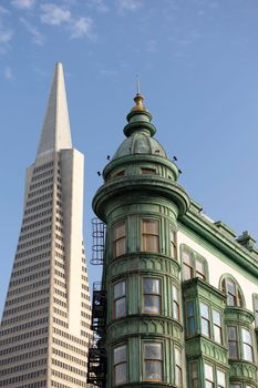
San Francisco - Photo 1
Photo by Stephen Leonardi

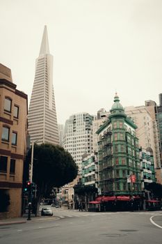
San Francisco - Photo 2
Photo by Stephen Leonardi
San Francisco - Photo 3
Photo by Airam Dato-on
San Francisco, United States
Click any image to view larger versionPast Weather Alerts
5 of 278Heat Advisory
* WHAT...High temperatures between 90 and 103 for interior valleys and higher elevations. High tempe...
Coastal Flood Advisory
* WHAT...Up to 1.5 ft of inundation above ground level is possible in low-lying areas near shoreline...
Coastal Flood Advisory
* WHAT...Up to 1.5 ft of inundation above ground level is possible in low-lying areas near shoreline...
Beach Hazards Statement
* WHAT...Increased risk of sneaker waves and strong rip currents due to long period southerly swell....
Coastal Flood Advisory
* WHAT...Up to 1.5 ft of inundation above ground level is possible in low-lying areas near shoreline...
Past Weather Alerts for San Francisco
Heat Advisory
* WHAT...High temperatures between 90 and 103 for interior valleys and higher elevations. High temperatures between 85 and 96 degrees for the Bay Shoreline. * WHERE...North Bay Interior Mountains and Valleys, and San Francisco Bay Shoreline. * WHEN...From noon to 11 PM PDT Thursday. * IMPACTS...This level of heat affects most individuals sensitive to heat, especially those without effective cooling and/or adequate hydration. Impacts possible in some health systems and in heat-sensitive industries.
Coastal Flood Advisory
* WHAT...Up to 1.5 ft of inundation above ground level is possible in low-lying areas near shorelines and tidal waterways. * WHERE...Bayshore regions near the San Francisco Bay. * WHEN...From 7 PM Thursday to 3 AM PDT Wednesday. * IMPACTS...Flooding of lots, parks, and roads with only isolated road closures expected. * ADDITIONAL DETAILS...At the San Francisco tidal gauge, high tide is expected to be 1.2 ft above normal (6.98 ft MLLW) at 8:51 PM on Thursday the 11th, 1.5 ft above normal (7.33 ft MLLW) at 9:34 PM on Friday the 12th, 1.8 ft above normal (7.58 ft MLLW) at 10:20 PM on Saturday the 13th, 1.3 ft above normal (7.10 ft MLLW) at 11:10 PM on Sunday the 14th, 1.2 ft above normal (7.05 ft MLLW) at 12:02 AM on Tuesday the 16th, and 1.0 ft above normal (6.81 ft MLLW) at 12:56 AM on Wednesday the 17th. High tide varies up to 90 minutes earlier or later along the Pacific Coast and through the San Francisco Bay, respectively.
Beach Hazards Statement
* WHAT...Increased risk of sneaker waves and strong rip currents due to long period southerly swell. * WHERE...Pacific Coast beaches, especially south and southwest facing beaches, across Sonoma, Marin, San Mateo, and Santa Cruz Counties. * WHEN...Through 9 PM Thursday evening. * IMPACTS...Dangerous swimming and surfing conditions and localized beach erosion can be expected. Sneaker waves can sweep across the shoreline without warning, pulling people into the sea from rocks, jetties and beaches.
Coastal Flood Advisory
* WHAT...Up to 1.5 ft of inundation above ground level is possible in low-lying areas near shorelines and tidal waterways. * WHERE...Bayshore regions of the North Bay along the San Pablo and San Francisco Bays. * WHEN...Until 3 AM PDT Wednesday. * IMPACTS...Flooding of lots, parks, and roads with only isolated road closures expected. * ADDITIONAL DETAILS...At the San Francisco tidal gauge, high tide is expected to be 1.2 ft above normal (6.98 ft MLLW) at 8:51 PM on Thursday the 11th, 1.5 ft above normal (7.33 ft MLLW) at 9:34 PM on Friday the 12th, 1.8 ft above normal (7.58 ft MLLW) at 10:20 PM on Saturday the 13th, 1.3 ft above normal (7.10 ft MLLW) at 11:10 PM on Sunday the 14th, 1.2 ft above normal (7.05 ft MLLW) at 12:02 AM on Tuesday the 16th, and 1.0 ft above normal (6.81 ft MLLW) at 12:56 AM on Wednesday the 17th. High tide varies up to 90 minutes earlier or later along the Pacific Coast and through the San Francisco Bay, respectively.
Beach Hazards Statement
* WHAT...An incoming long-period northwesterly swell will increase the risk of sneaker waves and strong rip currents. * WHERE...Beaches along the Pacific Coast. * WHEN...From Saturday morning through Sunday evening. * IMPACTS...Dangerous swimming and surfing conditions and localized beach erosion can be expected. Sneaker waves can sweep across the shoreline without warning, pulling people into the sea from rocks, jetties and beaches.
Heat Advisory
* WHAT...High temperatures in the low to mid 90s across the interior and 80s along the coastline. Reduced cooling overnight especially in the higher elevations. * WHERE...The Bay Area and Central Coast. * WHEN...Until 8 PM PDT Friday. * IMPACTS...This level of heat affects most individuals sensitive to heat, especially those without effective cooling and/or adequate hydration. Impacts possible in some health systems and in heat-sensitive industries. Hot conditions can cause heat illnesses. * ADDITIONAL DETAILS...Much above normal temperatures in the upper 80s to mid 90s are expected through the remainder of the week across the Bay Area and Central Coast. Portions of the interior Central Coast may reach the upper 90s starting mid to late week. Overnight lows in the upper 50s to low 60s will offer some relief to the lower elevations but will offer minimal relief within the higher elevations. Conditions will be much above normal along the coast this week but coastal residents may experience more relief overnight than those across the interior. The risk of heat related illnesses will increase with each additional day of heating from this event.
Heat Advisory
* WHAT...High temperatures in the low to mid 90s across the interior and 80s along the coastline. * WHERE...The Bay Area and Central Coast. * WHEN...Until 8 PM PDT Friday. * IMPACTS...This level of heat affects most individuals sensitive to heat, especially those without effective cooling and/or adequate hydration. Impacts possible in some health systems and in heat-sensitive industries. Hot conditions can cause heat illnesses. * ADDITIONAL DETAILS...Much above normal temperatures in the upper 80s to mid 90s are expected through the remainder of the week across the Bay Area and Central Coast. Portions of the interior Central Coast may reach the upper 90s starting mid to late week. Overnight lows in the upper 50s to low 60s will offer some relief to the lower elevations but will offer minimal relief within the higher elevations. Conditions will be much above normal along the coast this week but coastal residents may experience more relief overnight than those across the interior. The risk of heat related illnesses will increase with each additional day of heating from this event.
Cold Weather Advisory
* WHAT...Cold conditions with temperatures as low as 33 expected. Colder temperatures as low as 27 degrees for elevations above 2500 feet. * WHERE...East Bay Hills. * WHEN...From 1 AM to 9 AM PST Saturday. * IMPACTS...Cold conditions will be hazardous to sensitive populations such as unhoused individuals. Prolonged exposure to the cold conditions will lead to hypothermia for people, pets, and livestock. Cold conditions may damage or kill sensitive crops, plants, and vegetation if appropriate precautions are not taken.
Cold Weather Advisory
* WHAT...Cold conditions with temperatures as low as 33 expected. Slightly warmer conditions will be found across portions of the northern Salinas Valley and Carmel Valley where low temperatures range from 36 to 40 degrees. * WHERE...The Santa Clara Valley, North Bay Interior Valleys and Mountains, East Bay Interior Valleys, and Northern Salinas Valley and Hollister Valley. * WHEN...From 1 AM to 9 AM PST Saturday. * IMPACTS...Cold conditions will be hazardous to sensitive populations such as unhoused individuals. Prolonged exposure to the cold conditions will lead to hypothermia for people, pets, and livestock. Cold conditions may damage or kill sensitive crops, plants, and vegetation if appropriate precautions are not taken.
Cold Weather Advisory
* WHAT...Cold conditions with temperatures in the low-to-mid 30s expected. * WHERE...The Marin Hills, Western Sonoma County Hills, Northern Monterey Bay, The Santa Cruz Mountains, The Santa Clara Valley, Coastal North Bay Including Point Reyes National Seashore, San Francisco Bay Shoreline, and Northern Salinas Valley/Hollister Valley and Carmel Valley. * WHEN...From 1 AM to 9 AM PST Friday. * IMPACTS...Cold conditions will be hazardous to sensitive populations such as unhoused individuals. Prolonged exposure to the cold conditions will lead to hypothermia for people, pets, and livestock. Cold conditions may damage or kill sensitive crops, plants, and vegetation if appropriate precautions are not taken.
High Surf Advisory
* WHAT...Large breaking waves of 18 to 22 feet, with continuing increased risk of sneaker waves and strong rip currents. * WHERE...Pacific Coast beaches. * WHEN...Until 9 AM PST Friday. * IMPACTS...Dangerous swimming and surfing conditions and localized beach erosion can be expected. Sneaker waves can sweep across the shoreline without warning, pulling people into the sea from rocks, jetties and beaches. Large breaking waves can overpower swimmers resulting in significant physical injury and increase the risk of drowning.
Extreme Cold Warning
* WHAT...Very cold conditions with sub-freezing temperatures in the mid-20s to low-30s expected. * WHERE...The East Bay Hills and Valleys, Interior Monterey County and the Santa Lucia Range, Most of San Benito County and the Cholame Hills in Southeast Monterey County, North Bay Interior Mountains, North Bay Interior Valleys, Eastern Santa Clara Hills, and Southern Salinas Valley/Arroyo Seco and Lake San Antonio. * WHEN...From 1 AM to 9 AM PST Friday. * IMPACTS...Cold conditions will be hazardous to sensitive populations such as unhoused individuals. Cold conditions may damage or kill sensitive crops, plants, and vegetation if appropriate precautions are not taken. Prolonged exposure to the cold conditions will lead to hypothermia for people, pets, and livestock.
Wind Advisory
* WHAT...South winds 10 to 20 mph with gusts of 35 to 45 mph expected. * WHERE...Central Sacramento Valley, Northern Sacramento Valley, and Southern Sacramento Valley. * WHEN...Until 10 PM PST Thursday. * IMPACTS...Gusty winds will blow around unsecured objects. Tree limbs could be blown down and a few power outages may result. * ADDITIONAL DETAILS...Another round of gusty winds arrives late today and continues into Thursday.
Tsunami Warning
PZZ530-531-CAZ043-354-362-366-367-552-087-549-550-349-350- 340>342-346-529-530-006-505-506-508-509-109-104-103-101-ORZ021- 022-103-101-102-WAZ001-201-310-311-324>326-330>333-BCZ098- 099-096-097-AKZ328>332-323-324-326-327-318>322-325-317-731- 735-721>723-725-728-729-771>773-781-785-787-795-791-191846- /T.NEW.PAAQ.TS.W.9004.260219T1746Z-260219T1846Z/ Alaska, British Columbia, Washington, Oregon and California coastal areas ...THIS_MESSAGE_IS_FOR_TEST_PURPOSES_ONLY... ...THIS IS A TEST TO DETERMINE TRANSMISSION TIMES INVOLVED IN THE DISSEMINATION OF TSUNAMI INFORMATION... RESPONSES ARE REQUIRED FROM --------------------------- * All Coastal Weather Forecast Offices in Alaska, Washington, Oregon and California * USAF 11th Rescue Coordination Center at Elmendorf AFB * California, Oregon, Washington and Alaska State Warning Points * Emergency Management British Columbia * The Pacific Storm Prediction Centre in British Columbia * Joint Typhoon Warning Center in Hawaii * U.S. Coast Guard 11th, 13th, 17th District Offices * U.S. Coast Guard Kodiak COMMSTA and CAMSPAC Point Reyes, CA * Canadian Coast Guard MCTS COMOX and/or Victoria * FAA Regional Operations Center in Seattle * All Pacific Coast Tsunamiready Community Warning Points. RESPONSES SHOULD INCLUDE ------------------------ * Time-of-receipt * Agency name * Email address * Phone number Weather Service Offices should respond in accordance with local directives. All others should reply by one of the available methods below. SEND RESPONSE BY ---------------- * Email address - ntwc@noaa.gov * AFTN address - PAAQYQYX * AWIPS - TMA * Fax - 907-745-6071 ...THIS_MESSAGE_IS_FOR_TEST_PURPOSES_ONLY... ...THIS IS A TEST TO DETERMINE TRANSMISSION TIMES INVOLVED IN THE DISSEMINATION OF TSUNAMI INFORMATION...
Wind Advisory
* WHAT...South winds 15 to 25 mph with gusts of 35 to 45 mph expected. * WHERE...Sacramento Valley. * WHEN...Until 10 PM PST Thursday. * IMPACTS...Gusty winds will blow around unsecured objects. Tree limbs could be blown down and a few power outages may result. * ADDITIONAL DETAILS...A brief lull in stronger winds is expected on Wednesday, with another round of gusty winds late Wednesday into Thursday.
Cold Weather Advisory
* WHAT...Cold conditions with temperatures as low as 33 expected in the Santa Cruz Mountains. Cold conditions with temperatures as low as 34 expected in southern Santa Clara county and mid to upper 30s near San Jose. * WHERE...The Santa Cruz Mountains, and The Santa Clara Valley. * WHEN...Until 9 AM PST Wednesday. * IMPACTS...Cold conditions will be hazardous to sensitive populations such as unhoused individuals. Prolonged exposure to the cold conditions will lead to hypothermia for people, pets, and livestock. Cold conditions may damage or kill sensitive crops, plants, and vegetation if appropriate precautions are not taken.
Cold Weather Advisory
* WHAT...Cold conditions with temperatures as low as 32 expected. * WHERE...Southern Salinas Valley/Arroyo Seco and Lake San Antonio, North Bay Interior Mountains, and North Bay Interior Valleys. * WHEN...Until 9 AM PST Wednesday. * IMPACTS...Cold conditions will be hazardous to sensitive populations such as unhoused individuals. Prolonged exposure to the cold conditions will lead to hypothermia for people, pets, and livestock. Cold conditions may damage or kill sensitive crops, plants, and vegetation if appropriate precautions are not taken.
High Surf Advisory
* WHAT...Large breaking waves of 18 to 22 feet, with continuing increased risk of sneaker waves and strong rip currents. * WHERE...Pacific Coast beaches. * WHEN...From 3 AM Wednesday to 9 AM PST Friday. * IMPACTS...Dangerous swimming and surfing conditions and localized beach erosion can be expected. Sneaker waves can sweep across the shoreline without warning, pulling people into the sea from rocks, jetties and beaches. Large breaking waves can overpower swimmers resulting in significant physical injury and increase the risk of drowning.
Dense Fog Advisory
* WHAT...Visibility one quarter mile or less in dense fog. * WHERE...Carquinez Strait and Delta, Central/Southern Sacramento Valley, Northern San Joaquin Valley. * WHEN...From 11 PM this evening to noon PST Sunday. * IMPACTS...Low visibility could make driving conditions hazardous.
Beach Hazards Statement
* WHAT...An increased risk of sneaker waves and strong rip currents with breaking waves of 14 to 19 feet. * WHERE...Pacific Coast beaches. * WHEN...Through 9 AM PST Monday morning. * IMPACTS...Dangerous conditions are forecast along the shoreline. Hazards include sneaker waves, strong rip currents, and large breaking waves.
Coastal Flood Advisory
* WHAT...For the Beach Hazards Statement, an increased risk of sneaker waves and strong rip currents with breaking waves of 14 to 19 feet. For the Coastal Flood Advisory, up to 1.3 ft of inundation above ground level is possible in low-lying areas near shorelines and tidal waterways. * WHERE...San Francisco, the Monterey Bay and Big Sur Coast. * WHEN...For the Coastal Flood Advisory, until noon PST Sunday. For the Beach Hazards Statement, through 9 AM PST Monday morning. * IMPACTS...Flooding of lots, parks, and roads with only isolated road closures expected. Dangerous conditions are forecast along the shoreline. Hazards include sneaker waves, strong rip currents, and large breaking waves. * ADDITIONAL DETAILS...At the San Francisco tidal gauge, high tide is expected to be: 1.2 ft above normal (6.96 ft MLLW) at 10:22 AM Sunday 2/1. These predictions include up to 0.3 ft of storm surge from an incoming moderate to long period swell that will enhance the astronomical tide and flooding threat. High tide timing varies up to 90 minutes earlier or later along the Pacific Coast and through the San Francisco Bay, respectively.
Coastal Flood Advisory
* WHAT...Up to 1.3 ft of inundation above ground level is possible in low-lying areas near shorelines and tidal waterways. * WHERE...Bayshore locations along the San Francisco Bay and San Pablo Bay. * WHEN...Until noon PST Sunday. * IMPACTS...Flooding of lots, parks, and roads with only isolated road closures expected. * ADDITIONAL DETAILS...At the San Francisco tidal gauge, high tide is expected to be: 1.2 ft above normal (6.96 ft MLLW) at 10:22 AM Sunday 2/1. These predictions include up to 0.3 ft of storm surge from an incoming moderate to long period swell that will enhance the astronomical tide and flooding threat. High tide timing varies up to 90 minutes earlier or later along the Pacific Coast and through the San Francisco Bay, respectively.
Beach Hazards Statement
* WHAT...For the Beach Hazards Statement, an increased risk of sneaker waves and strong rip currents with breaking waves of 14 to 19 feet. For the Coastal Flood Advisory, up to 1.3 ft of inundation above ground level is possible in low-lying areas near shorelines and tidal waterways. * WHERE...San Francisco, the Monterey Bay and Big Sur Coast. * WHEN...For the Coastal Flood Advisory, until noon PST Sunday. For the Beach Hazards Statement, through 9 AM PST Monday morning. * IMPACTS...Flooding of lots, parks, and roads with only isolated road closures expected. Dangerous conditions are forecast along the shoreline. Hazards include sneaker waves, strong rip currents, and large breaking waves. * ADDITIONAL DETAILS...At the San Francisco tidal gauge, high tide is expected to be: 1.2 ft above normal (6.96 ft MLLW) at 10:22 AM Sunday 2/1. These predictions include up to 0.3 ft of storm surge from an incoming moderate to long period swell that will enhance the astronomical tide and flooding threat. High tide timing varies up to 90 minutes earlier or later along the Pacific Coast and through the San Francisco Bay, respectively.
Coastal Flood Advisory
* WHAT...For the Beach Hazards Statement, an increased risk of sneaker waves and strong rip currents with breaking waves of 14 to 19 feet. For the Coastal Flood Advisory, up to 1.3 ft of inundation above ground level is possible in low-lying areas near shorelines and tidal waterways. * WHERE...San Francisco and Monterey Bay. * WHEN...For the Coastal Flood Advisory, until noon PST Sunday. For the Beach Hazards Statement, through 9 AM PST Monday morning. * IMPACTS...Flooding of lots, parks, and roads with only isolated road closures expected. Dangerous conditions are forecast along the shoreline. Hazards include sneaker waves, strong rip currents, and large breaking waves. * ADDITIONAL DETAILS...At the San Francisco tidal gauge, high tide is expected to be: 1.3 ft above normal (7.20 ft MLLW) at 9:30 AM Saturday 1/31 and 1.2 ft above normal (6.96 ft MLLW) at 10:22 AM Sunday 2/1. These predictions include up to 0.3 ft of storm surge from an incoming moderate to long period swell that will enhance the astronomical tide and flooding threat. High tide timing varies up to 90 minutes earlier or later along the Pacific Coast and through the San Francisco Bay, respectively.
Beach Hazards Statement
* WHAT...For the Beach Hazards Statement, an increased risk of sneaker waves and strong rip currents with breaking waves of 14 to 19 feet. For the Coastal Flood Advisory, up to 1.3 ft of inundation above ground level is possible in low-lying areas near shorelines and tidal waterways. * WHERE...San Francisco and Monterey Bay. * WHEN...For the Coastal Flood Advisory, until noon PST Sunday. For the Beach Hazards Statement, through 9 AM PST Monday morning. * IMPACTS...Flooding of lots, parks, and roads with only isolated road closures expected. Dangerous conditions are forecast along the shoreline. Hazards include sneaker waves, strong rip currents, and large breaking waves. * ADDITIONAL DETAILS...At the San Francisco tidal gauge, high tide is expected to be: 1.3 ft above normal (7.20 ft MLLW) at 9:30 AM Saturday 1/31 and 1.2 ft above normal (6.96 ft MLLW) at 10:22 AM Sunday 2/1. These predictions include up to 0.3 ft of storm surge from an incoming moderate to long period swell that will enhance the astronomical tide and flooding threat. High tide timing varies up to 90 minutes earlier or later along the Pacific Coast and through the San Francisco Bay, respectively.
Coastal Flood Advisory
* WHAT...Up to 1.3 ft of inundation above ground level is possible in low-lying areas near shorelines and tidal waterways. * WHERE...Bayshore locations along the San Francisco Bay and San Pablo Bay. * WHEN...Until noon PST Sunday. * IMPACTS...Flooding of lots, parks, and roads with only isolated road closures expected. * ADDITIONAL DETAILS...At the San Francisco tidal gauge, high tide is expected to be: 1.3 ft above normal (7.20 ft MLLW) at 9:30 AM Saturday 1/31 and 1.2 ft above normal (6.96 ft MLLW) at 10:22 AM Sunday 2/1. These predictions include up to 0.3 ft of storm surge from an incoming moderate to long period swell that will enhance the astronomical tide and flooding threat. High tide timing varies up to 90 minutes earlier or later along the Pacific Coast and through the San Francisco Bay, respectively.
Beach Hazards Statement
* WHAT...An increased risk of sneaker waves and strong rip currents with breaking waves of 14 to 19 feet. * WHERE...Pacific Coast beaches. * WHEN...Through 9 AM PST Monday morning. * IMPACTS...Dangerous conditions are forecast along the shoreline. Hazards include sneaker waves, strong rip currents, and large breaking waves.
Dense Fog Advisory
* WHAT...Visibility one quarter mile or less in dense fog. * WHERE...Carquinez Strait and Delta, Central/Southern Sacramento Valley, Northern San Joaquin Valley. * WHEN...From midnight tonight to noon PST Saturday. * IMPACTS...Low visibility could make driving conditions hazardous.
Beach Hazards Statement
* WHAT...For the Beach Hazards Statement, an increased risk of sneaker waves and strong rip currents with breaking waves of 14 to 19 feet. For the Coastal Flood Advisory, up to 1.3 ft of inundation above ground level is possible in low-lying areas near shorelines and tidal waterways. * WHERE...San Francisco and Monterey Bay. * WHEN...For the Coastal Flood Advisory, until noon PST Sunday. For the Beach Hazards Statement, through Monday morning. * IMPACTS...Flooding of lots, parks, and roads with only isolated road closures expected. Dangerous conditions are forecast along the shoreline. Hazards include sneaker waves, strong rip currents, and large breaking waves. * ADDITIONAL DETAILS...At the San Francisco tidal gauge, high tide is expected to be: 1.3 ft above normal (7.20 ft MLLW) at 9:30 AM Saturday 1/31 and 1.2 ft above normal (6.96 ft MLLW) at 10:22 AM Sunday 2/1. These predictions include up to 0.3 ft of storm surge from an incoming moderate to long period swell that will enhance the astronomical tide and flooding threat. High tide timing varies up to 90 minutes earlier or later along the Pacific Coast and through the San Francisco Bay, respectively.
Coastal Flood Advisory
* WHAT...Up to 1.3 ft of inundation above ground level is possible in low-lying areas near shorelines and tidal waterways. * WHERE...Bayshore locations along the San Francisco Bay and San Pablo Bay. * WHEN...Until noon PST Sunday. * IMPACTS...Flooding of lots, parks, and roads with only isolated road closures expected. * ADDITIONAL DETAILS...At the San Francisco tidal gauge, high tide is expected to be: 1.3 ft above normal (7.20 ft MLLW) at 9:30 AM Saturday 1/31 and 1.2 ft above normal (6.96 ft MLLW) at 10:22 AM Sunday 2/1. These predictions include up to 0.3 ft of storm surge from an incoming moderate to long period swell that will enhance the astronomical tide and flooding threat. High tide timing varies up to 90 minutes earlier or later along the Pacific Coast and through the San Francisco Bay, respectively.
Beach Hazards Statement
* WHAT...An increased risk of sneaker waves and strong rip currents with breaking waves of 14 to 19 feet. * WHERE...Pacific Coast beaches. * WHEN...Through Monday morning. * IMPACTS...Dangerous conditions are forecast along the shoreline. Hazards include sneaker waves, strong rip currents, and large breaking waves.
Dense Fog Advisory
* WHAT...Visibility one quarter mile or less in dense fog. * WHERE...Carquinez Strait and Delta, Central/Southern Sacramento Valley, and Northern San Joaquin Valley. * WHEN...From midnight tonight to noon PST Friday. * IMPACTS...Low visibility could make driving conditions hazardous.
Beach Hazards Statement
* WHAT...For the Beach Hazards Statement, an increased risk of sneaker waves and strong rip currents with breaking waves of 14 to 19 feet. For the Coastal Flood Advisory, up to 1.4 ft of inundation above ground level is possible in low-lying areas near shorelines and tidal waterways. * WHERE...San Francisco and Monterey Bay. * WHEN...For the Beach Hazards Statement, through Monday morning. For the Coastal Flood Advisory, until noon PST Sunday. * IMPACTS...Flooding of lots, parks, and roads with only isolated road closures expected. Dangerous conditions are forecast along the shoreline. Hazards include sneaker waves, strong rip currents, and large breaking waves. * ADDITIONAL DETAILS...At the San Francisco tidal gauge, high tide is expected to be: 1.1 ft above normal (6.98 ft MLLW) at 8:34 AM Friday 1/30, 1.4 ft above normal (7.24 ft MLLW) at 9:30 AM Saturday 1/31, 1.3 ft above normal (7.16 ft MLLW) at 10:22 AM Sunday 2/1. These predictions include up to 0.4 ft of storm surge from an incoming moderate to long period swell that will enhance the astronomical tide and flooding threat. High tide timing varies up to 90 minutes earlier or later along the Pacific Coast and through the San Francisco Bay, respectively.
Coastal Flood Advisory
* WHAT...Up to 1.4 ft of inundation above ground level is possible in low-lying areas near shorelines and tidal waterways. * WHERE...Bayshore locations along the San Francisco Bay and San Pablo Bay. * WHEN...Until noon PST Sunday. * IMPACTS...Flooding of lots, parks, and roads with only isolated road closures expected. * ADDITIONAL DETAILS...At the San Francisco tidal gauge, high tide is expected to be: 1.1 ft above normal (6.98 ft MLLW) at 8:34 AM Friday 1/30, 1.4 ft above normal (7.24 ft MLLW) at 9:30 AM Saturday 1/31, 1.3 ft above normal (7.16 ft MLLW) at 10:22 AM Sunday 2/1. These predictions include up to 0.4 ft of storm surge from an incoming moderate to long period swell that will enhance the astronomical tide and flooding threat. High tide timing varies up to 90 minutes earlier or later along the Pacific Coast and through the San Francisco Bay, respectively.
Coastal Flood Advisory
* WHAT...Up to 1.4 ft of inundation above ground level is possible in low-lying areas near shorelines and tidal waterways. * WHERE...Bayshore locations along the San Francisco Bay and San Pablo Bay. * WHEN...From 6 AM Thursday to noon PST Sunday. * IMPACTS...Flooding of lots, parks, and roads with only isolated road closures expected. * ADDITIONAL DETAILS...At the San Francisco tidal gauge, high tide is expected to be: 1.2 ft above normal (7.02 ft MLLW) at 7:34 AM Thursday 1/29, 1.1 ft above normal (6.98 ft MLLW) at 8:34 AM Friday 1/30, 1.4 ft above normal (7.24 ft MLLW) at 9:30 AM Saturday 1/31, 1.3 ft above normal (7.16 ft MLLW) at 10:22 AM Sunday 2/1. These predictions include up to 0.4 ft of storm surge that will enhance the astronomical tide and flooding threat. High tide timing varies up to 90 minutes earlier or later along the Pacific Coast and through the San Francisco Bay, respectively.
Beach Hazards Statement
* WHAT...For the Beach Hazards Statement, an increased risk of sneaker waves and strong rip currents with breaking waves of 14 to 19 feet. For the Coastal Flood Advisory, up to 1.4 ft of inundation above ground level is possible in low-lying areas near shorelines and tidal waterways. * WHERE...San Francisco and Monterey Bay. * WHEN...For the Beach Hazards Statement, from 9 PM PST this evening through 9 AM PST Friday morning. For the Coastal Flood Advisory, from 6 AM PST Thursday to noon PST Sunday. * IMPACTS...Flooding of lots, parks, and roads with only isolated road closures expected. Dangerous conditions are forecast along the shoreline. Hazards include sneaker waves, strong rip currents, and large breaking waves. * ADDITIONAL DETAILS...At the San Francisco tidal gauge, high tide is expected to be: 1.2 ft above normal (7.02 ft MLLW) at 7:34 AM Thursday 1/29, 1.1 ft above normal (6.98 ft MLLW) at 8:34 AM Friday 1/30, 1.4 ft above normal (7.24 ft MLLW) at 9:30 AM Saturday 1/31, 1.3 ft above normal (7.16 ft MLLW) at 10:22 AM Sunday 2/1. These predictions include up to 0.4 ft of storm surge that will enhance the astronomical tide and flooding threat. High tide timing varies up to 90 minutes earlier or later along the Pacific Coast and through the San Francisco Bay, respectively.
Beach Hazards Statement
* WHAT...An increased risk of sneaker waves and strong rip currents with breaking waves of 14 to 19 feet. * WHERE...Pacific Coast beaches. * WHEN...From 9 PM PST this evening through 9 AM PST Friday morning. * IMPACTS...Dangerous conditions are forecast along the shoreline. Hazards include sneaker waves, strong rip currents, and large breaking waves.
Coastal Flood Advisory
* WHAT...For the Beach Hazards Statement, an increased risk of sneaker waves and strong rip currents with breaking waves of 14 to 19 feet. For the Coastal Flood Advisory, up to 1.4 ft of inundation above ground level is possible in low-lying areas near shorelines and tidal waterways. * WHERE...San Francisco and Monterey Bay. * WHEN...For the Beach Hazards Statement, from 9 PM PST this evening through 9 AM PST Friday morning. For the Coastal Flood Advisory, from 6 AM PST Thursday to noon PST Sunday. * IMPACTS...Flooding of lots, parks, and roads with only isolated road closures expected. Dangerous conditions are forecast along the shoreline. Hazards include sneaker waves, strong rip currents, and large breaking waves. * ADDITIONAL DETAILS...At the San Francisco tidal gauge, high tide is expected to be: 1.2 ft above normal (7.02 ft MLLW) at 7:34 AM Thursday 1/29, 1.1 ft above normal (6.98 ft MLLW) at 8:34 AM Friday 1/30, 1.4 ft above normal (7.24 ft MLLW) at 9:30 AM Saturday 1/31, 1.3 ft above normal (7.16 ft MLLW) at 10:22 AM Sunday 2/1. These predictions include up to 0.4 ft of storm surge that will enhance the astronomical tide and flooding threat. High tide timing varies up to 90 minutes earlier or later along the Pacific Coast and through the San Francisco Bay, respectively.
Dense Fog Advisory
* WHAT...Visibility one quarter mile or less in dense fog. * WHERE...Central Sacramento Valley, Southern Sacramento Valley, and Northern San Joaquin Valley. * WHEN...From midnight tonight to noon PST Thursday. * IMPACTS...Low visibility could make driving conditions hazardous.