San Juan
Current Weather
Clear Sky
Feels like: 26.6°C (79.9°F)
Sun Schedule
⚠️ Live forecasts now on mobile app only
This page is showing cached weather data. For real-time forecasts and updates for all cities, please download our mobile app:
City Images
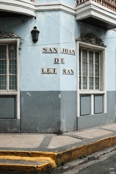
San Juan - Photo 1
Photo by Airam Dato-on
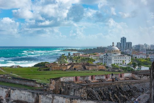
San Juan - Photo 2
Photo by Diego F. Parra
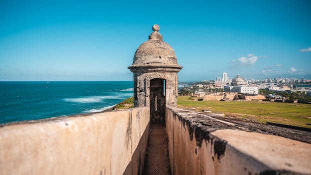
San Juan - Photo 3
Photo by Chait Goli
San Juan, United States
Click any image to view larger versionPast Weather Alerts
5 of 89Heat Advisory
* WHAT...This level of heat affect most individuals sensitive to heat, especially those without effe...
Rip Current Statement
* WHAT...Life-threatening rip currents. * WHERE...Exposed beaches of northern and southeastern Puer...
Wind Advisory
* WHAT...East winds up to 25 mph with gusts up to 40 mph expected, particularly across the U.S. Virg...
Rip Current Statement
* WHAT...For the High Surf Advisory, large breaking waves of 10 to 15. For the HIGH RIP CURRENT RISK...
High Surf Advisory
* WHAT...For the High Surf Advisory, large breaking waves of 10 to 15. For the HIGH RIP CURRENT RISK...
Past Weather Alerts for San Juan
Heat Advisory
* WHAT...This level of heat affect most individuals sensitive to heat, especially those without effective cooling and/or adequate hydration. Impacts possible in some health system and in heat-sensitive industries. * WHERE...Portions of Puerto Rico and Virgin Islands. * WHEN...From 10 AM this morning to 5 PM AST this afternoon. * IMPACTS...Hot temperatures and high humidity may cause heat illnesses.
Rip Current Statement
* WHAT...Life-threatening rip currents. * WHERE...Exposed beaches of northern and southeastern Puerto Rico, Vieques, Culebra, and all the U.S. Virgin Islands. * WHEN...Through Tuesday afternoon. * IMPACTS...Rip currents can sweep even the best swimmers away from shore into deeper water, where it becomes difficult to return to safety.
Wind Advisory
* WHAT...East winds up to 25 mph with gusts up to 40 mph expected, particularly across the U.S. Virgin Islands and eastern Puerto Rico. * WHERE...Puerto Rico and Virgin Islands. * WHEN...Until 8 PM AST this evening. * IMPACTS...Gusty winds will blow around unsecured objects. Tree limbs could be blown down and a few power outages may result.
Rip Current Statement
* WHAT...For the High Surf Advisory, large breaking waves of 10 to 15. For the HIGH RIP CURRENT RISK, life-threatening rip current. * WHERE... For the HIGH SURF ADVISORY, the most vulnerable areas for high surf and beach erosion include Pinones along Road 187, Parcelas Suarez, Villas del Mar, and Villa Christiana in Loiza; Fortuna in Luquillo; Pueblo and Tamarindo in Aguadilla; Barrio Obrero, Pueblo and Jareaito in Arecibo; Las Boca in Barceloneta; Machuca in Manati; Puerto Nuevo in Vega Baja; Ocean Park in San Juan; and Barrio Espinal in Aguada. For the HIGH RIP CURRENT RISK, along the north-facing beaches. * WHEN...For the High Rip Current Risk remains from 6 PM AST this evening through friday evening. For the High Surf Advisory from 4 AM tuesday to 6 PM AST wednesday * IMPACTS...FOR THE HIGH SURF ADVISORY, High waves that can wash over jetties and sweep people and pets onto jagged rocks. Rough surf may also knock you down. Large breaking waves will result in localized beach/dune structure erosion and dangerous swimming conditions. FOR THE HIGH RIP CURRENT RISK, rip currents can sweep even the best swimmers away from shore into deeper water, where it becomes difficult to return to safety.
High Surf Advisory
* WHAT...For the High Surf Advisory, large breaking waves of 10 to 15. For the HIGH RIP CURRENT RISK, life-threatening rip current. * WHERE... For the HIGH SURF ADVISORY, the most vulnerable areas for high surf and beach erosion include Pinones along Road 187, Parcelas Suarez, Villas del Mar, and Villa Christiana in Loiza; Fortuna in Luquillo; Pueblo and Tamarindo in Aguadilla; Barrio Obrero, Pueblo and Jareaito in Arecibo; Las Boca in Barceloneta; Machuca in Manati; Puerto Nuevo in Vega Baja; Ocean Park in San Juan; and Barrio Espinal in Aguada. For the HIGH RIP CURRENT RISK, along the north-facing beaches. * WHEN...For the High Rip Current Risk remains from 6 PM AST this evening through friday evening. For the High Surf Advisory from 4 AM tuesday to 6 PM AST wednesday * IMPACTS...FOR THE HIGH SURF ADVISORY, High waves that can wash over jetties and sweep people and pets onto jagged rocks. Rough surf may also knock you down. Large breaking waves will result in localized beach/dune structure erosion and dangerous swimming conditions. FOR THE HIGH RIP CURRENT RISK, rip currents can sweep even the best swimmers away from shore into deeper water, where it becomes difficult to return to safety.
Rip Current Statement
* WHAT...High Rip Current Risk, life-threatening rip current. * WHERE...Atlantic-exposed beaches of Puerto Rico, from the northwest to the northeast coast. * WHEN...From this evening through Friday evening. * IMPACTS...Rip currents can sweep even the best swimmers away from shore into deeper water, where it becomes difficult to return to safety.
Flood Advisory
* WHAT...Urban and small stream flooding caused by excessive rainfall is expected. * WHERE...Ciales, Jayuya, Morovis, Orocovis and Utuado. * WHEN...Until 500 PM AST. * IMPACTS...Dangerous flows over low-water crossings. Water over roadways. * ADDITIONAL DETAILS... - At 204 PM AST, Doppler radar indicated heavy rain due to thunderstorms. This will cause urban and small stream flooding.
Flood Advisory
* WHAT...Urban and small stream flooding caused by excessive rainfall is expected. * WHERE...Carolina, San Juan and Trujillo Alto. * WHEN...Until 330 PM AST. * IMPACTS...Minor flooding in low-lying and poor drainage areas. Water over roadways. * ADDITIONAL DETAILS... - At 132 PM AST, Doppler radar indicated heavy rain due to thunderstorms. This will cause urban and small stream flooding. Between 1 and 2 inches of rain have fallen. - Additional rainfall amounts up to 1 inch are expected over the area. This additional rain will result in minor flooding.
Flood Warning
Additional showers are expected to reach Rio Cibuco basin later this afternoon. The river could reach flood stage once again. * WHAT...Flooding caused by excessive rainfall continues. * WHERE...Rio Cibuco and its tributaries along Vega Alta and Vega Baja. * WHEN...Until 500 PM AST. * IMPACTS...Flooding of rivers, creeks, streams, and other low-lying and flood-prone locations is imminent or occurring. * ADDITIONAL DETAILS... - At 1158 AM AST, gauge reports indicated that Rio Cibuco is now in action stage. However, flooding is ongoing in the warned area.
Rip Current Statement
* WHAT...High Rip Current Risk, life-threatening rip current. * WHERE...Along the north-facing beaches from Rincon to Fajardo. * WHEN...From Sunday morning through late Sunday night. * IMPACTS...Rip currents can sweep even the best swimmers away from shore into deeper water, where it becomes difficult to return to safety.
Rip Current Statement
* WHAT...High Rip Current Risk, life-threatening rip currents. * WHERE...Along the exposed beaches in northern and eastern Puerto Rico, Culebra, Vieques, and the US Virgin Islands. * WHEN...From 6 AM AST Sunday through late Monday night. * IMPACTS...Rip currents can sweep even the best swimmers away from shore into deeper water, where it becomes difficult to return to safety.
Rip Current Statement
* WHAT...High Rip Current Risk, life-threatening rip currents. * WHERE...North and east-facing beaches of Puerto Rico and U.S. Virgin Islands. * WHEN...Through this afternoon. * IMPACTS...Rip currents can sweep even the best swimmers away from shore into deeper water, where it becomes difficult to return to safety.
Rip Current Statement
* WHAT...High Rip Current Risk, life-threatening rip current. * WHERE...North- and east-facing beaches of northern Puerto Rico and Sr Croix. * WHEN...From Wednesday morning through late Thursday night. * IMPACTS...Rip currents can sweep even the best swimmers away from shore into deeper water, where it becomes difficult to return to safety.
Rip Current Statement
* WHAT...High Rip Current Risk, life-threatening rip currents. * WHERE...North and east-facing beaches of Puerto Rico and St. Croix. * WHEN...From Wednesday morning through late Thursday night. * IMPACTS...Rip currents can sweep even the best swimmers away from shore into deeper water, where it becomes difficult to return to safety.
Rip Current Statement
* WHAT...Life-threatening rip currents. * WHERE...Along the north and east facing beaches from northwest to northeast PR, Culebra, St Thomas, St John and Adjacent Islands. * WHEN...Through late tonight. * IMPACTS...Rip currents can sweep even the best swimmers away from shore into deeper water, where it becomes difficult to return to safety.
Rip Current Statement
* WHAT...life-threatening rip current. * WHERE...along the north and east facing beaches from northwest to northeast PR, Culebra, St Thomas, St John and Adjacent Islands. * WHEN...through late tonight. * IMPACTS...rip currents can sweep even the best swimmers away from shore into deeper water, where it becomes difficult to return to safety.
High Surf Advisory
* WHAT...For the High Surf Advisory, large breaking waves of 10 to 12 feet. For the High Rip Current Risk, life-threatening rip current. * WHERE...For the High Surf Advisory, the most vulnerable areas for high surf and beach erosion include Pinones along Road 187, Parcelas Suarez, Villas del Mar, and Villa Christiana in Loiza; Fortuna in Luquillo; Pueblo and Tamarindo in Aguadilla; Barrio Obrero, Pueblo and Jarealito in Arecibo; Las Boca in Barceloneta; Machuca in Manati; Puerto Nuevo in Vega Baja; Ocean Park in San Juan; and Barrio Espinal in Aguada. Additionally, north-facing beaches of Culebra, St Thomas, and St John. For the High Rip Current Risk, beaches along the west to northeast coast of Puerto Rico. * WHEN...For the High Surf Advisory remains until 6 AM AST Friday. For the High Rip Current Risk remains through Friday afternoon. * IMPACTS...For the High Surf Advisory, high waves that can wash over jetties and sweep people and pets onto jagged rocks. Rough surf may also knock you down. Large breaking waves will result in localized beach/dune structure erosion and dangerous swimming conditions. For the High Rip Current Risk, rip currents can sweep even the best swimmers away from shore into deeper water, where it becomes difficult to return to safety.
Rip Current Statement
* WHAT...For the High Surf Advisory, large breaking waves of 10 to 13 feet. For the HIGH RIP CURRENT RISK, life-threatening rip currents. * WHERE... For the HIGH SURF ADVISORY, the most vulnerable areas for high surf and beach erosion include Pinones along Road 187, Parcelas Suarez, Villas del Mar, and Villa Christiana in Loiza; Fortuna in Luquillo; Pueblo and Tamarindo in Aguadilla; Barrio Obrero, Pueblo and Jareaito in Arecibo; Las Boca in Barceloneta; Machuca in Manati; Puerto Nuevo in Vega Baja; Ocean Park in San Juan; and Barrio Espinal in Aguada. For the HIGH RIP CURRENT RISK, northern coastal beaches of Puerto Rico. * WHEN...The High Surf Advisory remains in effect until 6 PM AST Friday. The High Rip Current Risk now in effect through Saturday afternoon. * IMPACTS...FOR THE HIGH SURF ADVISORY, High waves that can wash over jetties and sweep people and pets onto jagged rocks. Rough surf may also knock you down. Large breaking waves will result in localized beach/dune structure erosion and dangerous swimming conditions. FOR THE HIGH RIP CURRENT RISK, rip currents can sweep even the best swimmers away from shore into deeper water, where it becomes difficult to return to safety.
Rip Current Statement
* WHAT... Life-threatening rip current. * WHERE... Across the all north coast of Puerto Rico, including the Northwestern and northeastern, Culebra And St. Thomas and adjacent Islands.. * WHEN...Remains through saturday afternoon. * IMPACTS...FOR THE HIGH RIP CURRENT RISK, rip currents can sweep even the best swimmers away from shore into deeper water, where it becomes difficult to return to safety.
High Surf Advisory
* WHAT...For the High Surf Advisory, large breaking waves of 10 to 12 feet. For the HIGH RIP CURRENT RISK, life-threatening rip current. * WHERE... For the HIGH SURF ADVISORY, the most vulnerable areas for high surf and beach erosion include Pinones along Road 187, Parcelas Suarez, Villas del Mar, and Villa Christiana in Loiza; Fortuna in Luquillo; Pueblo and Tamarindo in Aguadilla; Barrio Obrero, Pueblo and Jareaito in Arecibo; Las Boca in Barceloneta; Machuca in Manati; Puerto Nuevo in Vega Baja; Ocean Park in San Juan; and Barrio Espinal in Aguada. For the HIGH RIP CURRENT RISK, along the exposed north-facing beaches. * WHEN...For the High Surf Advisory remains until 6 PM AST this evening. For the High Rip Current Risk remains through saturday afternoon. * IMPACTS...FOR THE HIGH SURF ADVISORY, High waves that can wash over jetties and sweep people and pets onto jagged rocks. Rough surf may also knock you down. Large breaking waves will result in localized beach/dune structure erosion and dangerous swimming conditions. FOR THE HIGH RIP CURRENT RISK, rip currents can sweep even the best swimmers away from shore into deeper water, where it becomes difficult to return to safety.
Rip Current Statement
* WHAT...For the High Surf Advisory, large breaking waves of 10 to 12 feet. For the HIGH RIP CURRENT RISK, life-threatening rip current. * WHERE... For the HIGH SURF ADVISORY, the most vulnerable areas for high surf and beach erosion include Pinones along Road 187, Parcelas Suarez, Villas del Mar, and Villa Christiana in Loiza; Fortuna in Luquillo; Pueblo and Tamarindo in Aguadilla; Barrio Obrero, Pueblo and Jareaito in Arecibo; Las Boca in Barceloneta; Machuca in Manati; Puerto Nuevo in Vega Baja; Ocean Park in San Juan; and Barrio Espinal in Aguada. For the HIGH RIP CURRENT RISK, along the exposed north-facing beaches. * WHEN...For the High Surf Advisory remains until 6 PM AST this evening. For the High Rip Current Risk remains through saturday afternoon. * IMPACTS...FOR THE HIGH SURF ADVISORY, High waves that can wash over jetties and sweep people and pets onto jagged rocks. Rough surf may also knock you down. Large breaking waves will result in localized beach/dune structure erosion and dangerous swimming conditions. FOR THE HIGH RIP CURRENT RISK, rip currents can sweep even the best swimmers away from shore into deeper water, where it becomes difficult to return to safety.
High Surf Advisory
* WHAT...For the High Surf Advisory, large breaking waves of 10 to 13 feet. For the HIGH RIP CURRENT RISK, life-threatening rip currents. * WHERE... For the HIGH SURF ADVISORY, the most vulnerable areas for high surf and beach erosion include Pinones along Road 187, Parcelas Suarez, Villas del Mar, and Villa Christiana in Loiza; Fortuna in Luquillo; Pueblo and Tamarindo in Aguadilla; Barrio Obrero, Pueblo and Jareaito in Arecibo; Las Boca in Barceloneta; Machuca in Manati; Puerto Nuevo in Vega Baja; Ocean Park in San Juan; and Barrio Espinal in Aguada. For the HIGH RIP CURRENT RISK, northern coastal beaches of Puerto Rico. * WHEN...The High Surf Advisory remains in effect until 6 PM AST Friday. The High Rip Current Risk now in effect through Saturday afternoon. * IMPACTS...FOR THE HIGH SURF ADVISORY, High waves that can wash over jetties and sweep people and pets onto jagged rocks. Rough surf may also knock you down. Large breaking waves will result in localized beach/dune structure erosion and dangerous swimming conditions. FOR THE HIGH RIP CURRENT RISK, rip currents can sweep even the best swimmers away from shore into deeper water, where it becomes difficult to return to safety.
High Surf Advisory
* WHAT...Localized beach erosion and dangerous swimming conditions due to large breaking waves. * WHERE...The most vulnerable areas for high surf and beach erosion include Pinones along Road 187, Parcelas Suarez, Villas del Mar, and Villa Christiana in Loiza; Fortuna in Luquillo; Pueblo and Tamarindo in Aguadilla; Barrio Obrero, Pueblo and Jareaito in Arecibo; Las Boca in Barceloneta; Machuca in Manati; Puerto Nuevo in Vega Baja; Ocean Park in San Juan; and Barrio Espinal in Aguada. * WHEN...For the High Rip Current Risk remains in effect through late friday night. For the High Surf Advisory until 6 PM AST friday. * IMPACTS...For the High Surf Advisory, High waves that can wash over jetties and sweep people and pets onto jagged rocks. Rough surf may also knock you down. Large breaking waves will result in localized beach/dune structure erosion and dangerous swimming conditions. For the High Rip Current Risk, rip currents can sweep even the best swimmers away from shore into deeper water, where it becomes difficult to return to safety. * ADDITIONAL DETAILS...A long-period northerly swell is approaching the Atlantic beaches of the islands, expected to spread across the local waters over the next few days. This swell is expected to produce large breaking waves between 6 and 12 feet, particularly by noon today through Friday. Large breaking waves of High Surf Advisory criteria will likely reach the northern coastline by midday today. However, stronger pulses of the swell can even arrive earlier. Therefore, the High Surf Advisory was issued starting early today.
Rip Current Statement
* WHAT...Life-threatening rip currents. * WHERE...Beaches along the northwest to northeast coasts of Puerto Rico, Culebra, St. Thomas, and St. John. * WHEN...Through late Friday night. * IMPACTS...Rip currents can sweep even the best swimmers away from shore into deeper water, where it becomes difficult to return to safety. * ADDITIONAL DETAILS...A long-period northerly swell is approaching the Atlantic beaches of the islands, expected to spread across the local waters over the next few days. This swell is expected to produce large breaking waves between 6 and 12 feet, particularly after noon Thursday through Friday. High surf conditions and life- threatening rip currents are expected along the northwest to northeast coasts of PR, Culebra, and the northern U.S. Virgin Islands. A High Surf Advisory could be issued later tonight or tomorrow.
Rip Current Statement
* WHAT...Life-threatening rip currents. * WHERE...Northwest to northeast beaches of Puerto Rico, including Culebra & the northern U.S. Virgin Islands. * WHEN...Through late tonight. * IMPACTS...Rip currents can sweep even the best swimmers away from shore into deeper water, where it becomes difficult to return to safety.
Rip Current Statement
* WHAT...Life-threatening rip currents. * WHERE...Northwest to northeast beaches of Puerto Rico, including Culebra & the northern U.S. Virgin Islands. * WHEN...Through late Saturday Night. * IMPACTS...Rip currents can sweep even the best swimmers away from shore into deeper water, where it becomes difficult to return to safety.
Rip Current Statement
* WHAT...Life-threatening rip currents. * WHERE...Beaches along the northwest to east coasts of the islands. * WHEN...Through this evening. * IMPACTS...Rip currents can sweep even the best swimmers away from shore into deeper water, where it becomes difficult to return to safety.
Rip Current Statement
* WHAT...Life-threatening rip currents. * WHERE...Beaches along the northwest to east coasts of the islands. * WHEN...Through Thursday afternoon. * IMPACTS...Rip currents can sweep even the best swimmers away from shore into deeper water, where it becomes difficult to return to safety.
Rip Current Statement
* WHAT...Life-threatening rip currents. * WHERE...Beaches along the northwest to east coasts of the islands. * WHEN...Through Friday night. * IMPACTS...Rip currents can sweep even the best swimmers away from shore into deeper water, where it becomes difficult to return to safety.
Rip Current Statement
* WHAT...Life-threatening rip currents. * WHERE...Beaches along the northwest to east coasts of the islands. * WHEN...Through late tonight. * IMPACTS...Rip currents can sweep even the best swimmers away from shore into deeper water, where it becomes difficult to return to safety.
Rip Current Statement
* WHAT...Life-threatening rip currents. * WHERE...Beaches along the northwest to east coasts of the islands. * WHEN...Through late Tuesday night. * IMPACTS...Rip currents can sweep even the best swimmers away from shore into deeper water, where it becomes difficult to return to safety.
Rip Current Statement
* WHAT...Life-threatening rip currents. * WHERE...Beaches along the northwest to east coasts of the islands. * WHEN...Through late Monday night. * IMPACTS...Rip currents can sweep even the best swimmers away from shore into deeper water, where it becomes difficult to return to safety.
Rip Current Statement
* WHAT...Life-threatening rip current. * WHERE...Beaches along the northwest to northeast coast of Puerto Rico. * WHEN...Through 6 PM AST. * IMPACTS...Rip currents can sweep even the best swimmers away from shore into deeper water, where it becomes difficult to return to safety.
Rip Current Statement
* WHAT...Life-threatening rip currents. * WHERE...North-facing beaches of Puerto Rico, from Aguadilla to Fajardo, as well as Culebra. * WHEN...Through late tonight. * IMPACTS...Rip currents can sweep even the best swimmers away from shore into deeper water, where it becomes difficult to return to safety.
Rip Current Statement
* WHAT...Life-threatening rip currents. * WHERE...North-facing beaches of Puerto Rico, from Aguadilla to Fajardo, as well as Culebra. * WHEN...Through Wednesday afternoon. * IMPACTS...Rip currents can sweep even the best swimmers away from shore into deeper water, where it becomes difficult to return to safety.
Rip Current Statement
* WHAT...Life-threatening rip currents. * WHERE...North-facing beaches of Puerto Rico, including Culebra, and St. Thomas and St. John in the U.S. Virgin Islands. * WHEN...Through late Tuesday afternoon. * IMPACTS...Rip currents can sweep even the best swimmers away from shore into deeper water, where it becomes difficult to return to safety.
Rip Current Statement
* WHAT...Life-threatening rip currents. * WHERE...North-facing beaches of Puerto Rico, including Culebra, and St. Thomas and St. John in the U.S. Virgin Islands. * WHEN...Through late Monday night . * IMPACTS...Rip currents can sweep even the best swimmers away from shore into deeper water, where it becomes difficult to return to safety.
Rip Current Statement
* WHAT...For the High Surf Advisory, large breaking waves of 8 to 10 feet. For the HIGH RIP CURRENT RISK, life-threatening rip current. * WHERE...North-facing beaches of Puerto Rico, including Culebra, and the northern US Virgin Islands. * WHEN...Through late Monday night . * IMPACTS...Rip currents can sweep even the best swimmers away from shore into deeper water, where it becomes difficult to return to safety.
Rip Current Statement
* WHAT...For the High Surf Advisory, large breaking waves of 10 to 12 feet. For the High Rip Current Risk, life-threatening rip current. * WHERE...For the HIGH SURF ADVISORY, the most vulnerable areas for high surf and beach erosion include Pinones along Road 187, Parcelas Suarez, Villas del Mar, and Villa Christiana in Loiza; Fortuna in Luquillo; Pueblo and Tamarindo in Aguadilla; Barrio Obrero, Pueblo and Jarealito in Arecibo; Las Boca in Barceloneta; Machuca in Manati; Puerto Nuevo in Vega Baja; Ocean Park in San Juan; and Barrio Espinal in Aguada. For the High Rip Current Risk, exposed beaches of western, northern and eastern Puerto Rico, from Mayaguez eastward to Humacao. * WHEN...For the High Surf Advisory remains until 6 PM AST this evening. For the High Rip Current Risk remains through late Sunday night. * IMPACTS...FOR THE HIGH SURF ADVISORY, High waves that can wash over jetties and sweep people and pets onto jagged rocks. Rough surf may also knock you down. Large breaking waves will result in localized beach/dune structure erosion and dangerous swimming conditions. FOR THE HIGH RIP CURRENT RISK, rip currents can sweep even the best swimmers away from shore into deeper water, where it becomes difficult to return to safety.
High Surf Advisory
* WHAT...For the High Surf Advisory, large breaking waves of 10 to 12 feet. For the High Rip Current Risk, life-threatening rip current. * WHERE...For the HIGH SURF ADVISORY, the most vulnerable areas for high surf and beach erosion include Pinones along Road 187, Parcelas Suarez, Villas del Mar, and Villa Christiana in Loiza; Fortuna in Luquillo; Pueblo and Tamarindo in Aguadilla; Barrio Obrero, Pueblo and Jarealito in Arecibo; Las Boca in Barceloneta; Machuca in Manati; Puerto Nuevo in Vega Baja; Ocean Park in San Juan; and Barrio Espinal in Aguada. For the High Rip Current Risk, exposed beaches of western, northern and eastern Puerto Rico, from Mayaguez eastward to Humacao. * WHEN...For the High Surf Advisory remains until 6 PM AST this evening. For the High Rip Current Risk remains through late Sunday night. * IMPACTS...FOR THE HIGH SURF ADVISORY, High waves that can wash over jetties and sweep people and pets onto jagged rocks. Rough surf may also knock you down. Large breaking waves will result in localized beach/dune structure erosion and dangerous swimming conditions. FOR THE HIGH RIP CURRENT RISK, rip currents can sweep even the best swimmers away from shore into deeper water, where it becomes difficult to return to safety.