Whidbey Island
Current Weather
Clear Sky
Feels like: 11.9°C (53.4°F)
Sun Schedule
⚠️ Live forecasts now on mobile app only
This page is showing cached weather data. For real-time forecasts and updates for all cities, please download our mobile app:
City Images
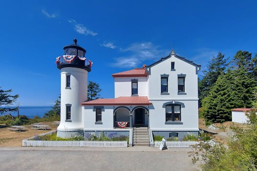
Whidbey Island - Photo 1
Photo by William Jacobs
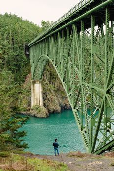
Whidbey Island - Photo 2
Photo by Makayla Asuncion
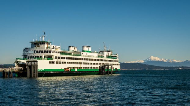
Whidbey Island - Photo 3
Photo by William Jacobs
Whidbey Island, United States
Click any image to view larger versionPast Weather Alerts
5 of 50Small Craft Advisory
* WHAT...For the Small Craft Advisory, west winds 15 to 25 kt. For the Gale Watch, west winds 15 to ...
Gale Watch
* WHAT...For the Small Craft Advisory, west winds 15 to 25 kt. For the Gale Watch, west winds 15 to ...
wind
Damaging winds are expected. When: Tonight Where: West Vancouver Island - south of Sooke, souther...
Winter Weather Advisory
* WHAT...Snow expected. Total snow accumulations between 8 and 12 inches. * WHERE...Cascades of Sno...
Wind Advisory
* WHAT...Southerly winds 20 to 30 mph with gusts up to 45 mph expected. * WHERE...Island County, Lo...
Past Weather Alerts for Whidbey Island
Small Craft Advisory
* WHAT...For the Small Craft Advisory, west winds 15 to 25 kt. For the Gale Watch, west winds 15 to 25 kt with gusts up to 35 kt possible. * WHERE...Central U. S. Waters Strait Of Juan De Fuca and East Entrance U. S. Waters Strait Of Juan De Fuca. * WHEN...For the Small Craft Advisory, until 8 AM PDT Tuesday. For the Gale Watch, from Tuesday afternoon through Tuesday evening. * IMPACTS...Strong winds can cause hazardous seas which could capsize or damage vessels and reduce visibility. * ADDITIONAL DETAILS...Gales are expected to weaken after 03Z.
Gale Watch
* WHAT...For the Small Craft Advisory, west winds 15 to 25 kt. For the Gale Watch, west winds 15 to 25 kt with gusts up to 35 kt possible. * WHERE...Central U. S. Waters Strait Of Juan De Fuca and East Entrance U. S. Waters Strait Of Juan De Fuca. * WHEN...For the Small Craft Advisory, until 8 AM PDT Tuesday. For the Gale Watch, from Tuesday afternoon through Tuesday evening. * IMPACTS...Strong winds can cause hazardous seas which could capsize or damage vessels and reduce visibility. * ADDITIONAL DETAILS...Gales are expected to weaken after 03Z.
wind
Damaging winds are expected. When: Tonight Where: West Vancouver Island - south of Sooke, southern tip of Greater Victoria Remark: Strong westerly winds 70-90 km/h will ease overnight. ### Local utility outages are possible. Damage to roofs, fences, branches or soft shelters is possible. Please continue to monitor alerts and forecasts issued by Environment Canada. To report severe weather, send an email to BCstorm@ec.gc.ca or post reports on X using #BCStorm.
Winter Weather Advisory
* WHAT...Snow expected. Total snow accumulations between 8 and 12 inches. * WHERE...Cascades of Snohomish and Northern King Counties and Cascades of Whatcom and Skagit Counties. * WHEN...Until 5 AM PDT Thursday. * IMPACTS...Travel could be very difficult. * ADDITIONAL DETAILS...A convergence zone will develop Wednesday afternoon which could bring a period of locally heavier snow, especially at Stevens Pass.
Wind Advisory
* WHAT...Southerly winds 20 to 30 mph with gusts up to 45 mph expected. * WHERE...Island County, Lowlands of Western Skagit and Northwestern Snohomish Counties, Lowlands of Western Whatcom County, Port Townsend Area, and San Juan County. * WHEN...From 11 AM to 6 PM PDT Tuesday. * IMPACTS...Gusty winds could blow around unsecured objects. Tree limbs could be blown down and a few power outages may result.
Flood Warning
...The Flood Warning continues for the following rivers in Washington... Snohomish River At Snohomish affecting Snohomish County. * WHAT...Minor flooding is occurring and minor flooding is forecast. * WHERE...Snohomish River at Snohomish. * WHEN...Until just after midnight tonight. * IMPACTS...At 25.0 feet, the Snohomish River will cause minor flooding of lowlands not protected by levees and on the Old Snohomish-Monroe highway. A stage of 25 feet on the Snohomish River corresponds to a Phase 2 in the Snohomish County flood program. * ADDITIONAL DETAILS... - At 9:00 AM PDT Sunday the stage was 26.1 feet. - Flood stage is 25.0 feet. - Recent Activity...The maximum river stage in the 24 hours ending at 9:00 AM PDT Sunday was 29.0 feet. - Forecast...The river will oscillate above flood stage with a maximum value of 26.0 feet late this morning. It will fall below flood stage late this evening. - Flood History...This crest compares to a previous crest of 25.9 feet on 11/26/1950. - http://www.weather.gov/safety/flood
Flood Warning
...The Flood Warning is extended for the following rivers in Washington... Snohomish River Near Monroe affecting Snohomish County. ...The Flood Warning continues for the following rivers in Washington... Snohomish River At Snohomish affecting Snohomish County. * WHAT...Minor flooding is occurring. * WHERE...Snohomish River near Monroe. * WHEN...Until this afternoon. * IMPACTS...At 15.0 feet, the Snohomish River will cause minor flooding of low pasture lands and several roads near the river. A stage of 15 feet at this location corresponds to Phase 2 in the Snohomish County Flood Warning System. * ADDITIONAL DETAILS... - At 1:15 AM PDT Sunday the stage was 15.2 feet. - Flood stage is 15.0 feet. - Recent Activity...The maximum river stage in the 24 hours ending at 1:15 AM PDT Sunday was 17.9 feet. - Forecast...The river is expected to fall below flood stage early this morning and continue falling to 6.9 feet late Wednesday morning. - http://www.weather.gov/safety/flood
Flood Warning
...The Flood Warning is extended for the following rivers in Washington... Snohomish River Near Monroe affecting Snohomish County. ...The Flood Warning continues for the following rivers in Washington... Snohomish River At Snohomish affecting Snohomish County. * WHAT...Moderate flooding is occurring and moderate flooding is forecast. * WHERE...Snohomish River at Snohomish. * WHEN...Until late tonight. * IMPACTS...At 27.0 feet, the Snohomish River will flood several roads...including the Snohomish-Monroe highway...and low areas of the lower Snohomish valley that are not protected by levees. A stage of 27 feet on the Snohomish River corresponds roughly to a Phase 2 in the Snohomish County flood program. * ADDITIONAL DETAILS... - At 1:00 AM PDT Sunday the stage was 27.7 feet. - Flood stage is 25.0 feet. - Recent Activity...The maximum river stage in the 24 hours ending at 1:00 AM PDT Sunday was 30.4 feet. - Forecast...The river will oscillate above flood stage with a maximum value of 27.7 feet early this morning. It will fall below flood stage this afternoon. - http://www.weather.gov/safety/flood
Special Weather Statement
Rainfall amounts of 2 to 9 inches over the past 3 days has increased soil moisture to high levels across western Washington. This amount of rain that has been observed will continue to put extra pressure on soil instability, leading to an increased threat of landslides and debris flows, especially from recent burned areas. Over the last couple days multiple slides have been reported across locations of western Washington. More landslides are possible. Areas most susceptible to landslides debris flows under these conditions are steep coastal bluffs, other steep hillsides or road cuts, and recent burned areas. A diminishing threat of landslides and debris flows will continue over the weekend after the rain ends. For more information about current conditions, visit www.weather.gov/seattle, select Hydrology, and then scroll down for the links to the landslide information pages. For more information on landslides, visit the website for the Washington State Department of Natural Resources landslide geologic hazards at: http://bit.ly/2mtA3wn
Flood Warning
...The Flood Warning continues for the following rivers in Washington... Stillaguamish River At Arlington affecting Snohomish County. * WHAT...Minor flooding is occurring. * WHERE...Stillaguamish River at Arlington. * WHEN...Until late tomorrow morning. * IMPACTS...At 14.0 feet, the Stillaguamish River will locally spill over its banks. Minor flooding around Silvana will occur... including over Pioneer Highway. A stage of 14 feet on the Stillaguamish River corresponds roughly to Phase 2 in the Snohomish County Flood program. * ADDITIONAL DETAILS... - At 10:25 PM PDT Friday the stage was 14.0 feet. - Flood stage is 14.0 feet. - Recent Activity...The maximum river stage in the 24 hours ending at 10:25 PM PDT Friday was 17.1 feet. - Forecast...The river is expected to fall to 5.7 feet Monday afternoon. - http://www.weather.gov/safety/flood
Flood Warning
...The Flood Warning is extended for the following rivers in Washington... Snohomish River Near Monroe affecting Snohomish County. * WHAT...Major flooding is occurring and major flooding is forecast. * WHERE...Snohomish River near Monroe. * WHEN...Until early Sunday morning. * IMPACTS...At 17.0 feet, the Snohomish River will cause major flooding...inundating farm land...roads...and some residential areas. Levees will likely suffer damage. Flooding will occur all along the river including headwaters...tributaries...and other streams within and near the Snohomish River Basin. A stage of 17 feet at this location corresponds to Phase 2 in the Snohomish County Flood Warning System. * ADDITIONAL DETAILS... - At 7:15 PM PDT Friday the stage was 17.7 feet. - Flood stage is 15.0 feet. - Recent Activity...The maximum river stage in the 24 hours ending at 7:15 PM PDT Friday was 17.7 feet. - Forecast...The river is expected to rise and to crest in major flood stage around 18.3 feet tonight. The river will then slowly recede and be below flood stage by Saturday evening. It will then further recede on Sunday. - Flood History...This crest compares to a previous crest of 18.0 feet on 02/16/1982. - http://www.weather.gov/safety/flood
Flood Warning
...The Flood Warning is extended for the following rivers in Washington... South Fork Stillaguamish River Near Jordan Rd. Bridge affecting Snohomish County. * WHAT...Minor flooding is forecast. * WHERE...South Fork Stillaguamish River near Jordan Rd. Bridge. * WHEN...Until just after midnight tonight. * IMPACTS...At 211.0 feet, the South Fork Stillaguamish River will cause flooding along the river and tributaries. A stage of 14.5 feet corresponds to Phase 2 in the Snohomish County Flood Warning System. * ADDITIONAL DETAILS... - At 1:30 PM PDT Friday the stage was 210.5 feet. - Flood stage is 211.0 feet. - Forecast...The river is expected to rise above flood stage late this afternoon to a crest of 211.0 feet late this afternoon. It will then fall below flood stage late tonight. - Flood History...No available flood history. - http://www.weather.gov/safety/flood
Flood Warning
...Forecast flooding changed from Minor to Moderate severity and increased in duration for the following rivers in Washington... Stillaguamish River At Arlington affecting Snohomish County. * WHAT...Minor flooding is occurring and moderate flooding is forecast. * WHERE...Stillaguamish River at Arlington. * WHEN...Until tomorrow afternoon. * IMPACTS...At 17.0 feet, the Stillaguamish River will cause flooding mainly in the Silvana area, along Norman Road and in Florence. A stage of 17 feet on the Stillaguamish River corresponds roughly to Phase 3 in the Snohomish County Flood program. * ADDITIONAL DETAILS... - At 2:25 PM PDT Friday the stage was 16.8 feet. - Flood stage is 14.0 feet. - Recent Activity...The maximum river stage in the 24 hours ending at 2:25 PM PDT Friday was 16.9 feet. - Forecast...The river is expected to rise below flood stage late tonight and continue falling to 18.0 feet late tonight. - Flood History...This crest compares to a previous crest of 17.9 feet on 12/28/1949. - http://www.weather.gov/safety/flood
Winter Weather Advisory
* WHAT...Snow. Additional snow accumulations up to one inch. Winds gusting as high as 35 mph. * WHERE...Cascades of Snohomish and Northern King Counties. * WHEN...Until 4 AM PST Friday. * IMPACTS...Snow-covered roads and travel delays possible across the passes. Expect difficult travel conditions at times. Temporary pass closures possible. Gusty winds may down tree branches.
Winter Weather Advisory
* WHAT...Snow. Additional snow accumulations up to 3 inches. Winds gusting as high as 35 mph. * WHERE...Cascades of Snohomish and Northern King Counties. * WHEN...Until 4 AM PST Friday. * IMPACTS...Roads, and especially bridges and overpasses, will likely become slick and hazardous.
Winter Weather Advisory
* WHAT...Snow expected. Total snow accumulations up to 10 inches. Winds gusting as high as 35 mph. * WHERE...Cascades of Snohomish and Northern King Counties. * WHEN...Until 4 AM PST Friday. * IMPACTS...Snow-covered roads and travel delays possible across the passes. Expect difficult travel conditions at times. Temporary pass closures possible. Gusty winds may down tree branches. * ADDITIONAL DETAILS...Highest snowfall totals will be in the higher elevation backcountry. Amounts at Stevens Pass will likely be lower, with up to 4-6" expected at pass level.
Winter Weather Advisory
* WHAT...Snow expected. Total snow accumulations 8 to 12 inches. * WHERE...Cascades of Snohomish and Northern King Counties and Cascades of Whatcom and Skagit Counties. * WHEN...Until 1 PM PST Monday. * IMPACTS...Travel could be very difficult to impossible. The hazardous conditions could impact the Monday morning commute. * ADDITIONAL DETAILS...Snow levels will range between 3000 to 4000 feet.
wind
Strong winds that may cause damage are expected. What: Southeast winds gusting to 90 km/h When: Sunday morning Where: Neighbourhoods near Haro Strait and Juan de Fuca Strait Additional information: Southeast winds will rise early Sunday morning with gusts up to 90 km/h near Haro Strait and Juan de Fuca Strait as a disturbance passes near Vancouver Island. Conditions will remain blustery Sunday afternoon before the winds abate early Sunday evening. ### Local utility outages are possible. Damage to roofs, fences, branches or soft shelters is possible. There is a risk of injury due to flying or falling debris. Please continue to monitor alerts and forecasts issued by Environment Canada. To report severe weather, send an email to BCstorm@ec.gc.ca or post reports on X using #BCStorm.
wind
Strong winds that may cause damage are expected. What: Southeast winds gusting to 100 km/h over exposed coastal sections When: Late this evening to noon on Sunday Where: Exposed coastal sections of West Vancouver Island Additional information: A deep low pressure system off the coast of Vancouver Island will generate southeast winds of 80 km/h gusting to 100 beginning late this evening over exposed coastal sections of West Vancouver Island. These winds will begin to diminish near noon on Sunday as the low weakens and departs the area. ### Please continue to monitor alerts and forecasts issued by Environment Canada. To report severe weather, send an email to BCstorm@ec.gc.ca or post reports on X using #BCStorm.
Wind Advisory
* WHAT...East to southeast winds 20 to 30 mph with gusts up to 45 mph expected. * WHERE...Foothills and Valleys of Central King County, Foothills and Valleys of Pierce and Southern King Counties, and Foothills and Valleys of Snohomish and Northern King Counties. * WHEN...Until 10 AM PST Sunday. * IMPACTS...Gusty winds could blow around unsecured objects. Tree limbs could be blown down and a few power outages may result.
Cold Weather Advisory
* WHAT...Very cold wind chills as low as 10 to 15 degrees expected. * WHERE...Lowlands of Western Whatcom County and San Juan County. * WHEN...Until noon PST Thursday. * IMPACTS...Very cold temperatures can lead to hypothermia with prolonged exposure.
Cold Weather Advisory
* WHAT...Very cold wind chills as low as 15 to 20 degrees expected. * WHERE...Eastern Strait of Juan de Fuca, Island County, Lake Crescent Area Including US 101, Port Townsend Area, and Western Strait of Juan de Fuca. * WHEN...From 1 AM to 10 AM PST Thursday. * IMPACTS...Very cold temperatures can lead to hypothermia with prolonged exposure.
Cold Weather Advisory
* WHAT...Very cold wind chills as low as 20 to 25 expected. * WHERE...Downtown Everett / Marysville Area. * WHEN...From 1 AM to 10 AM PST Thursday. * IMPACTS...Very cold temperatures can lead to hypothermia with prolonged exposure.
Cold Weather Advisory
* WHAT...Very cold wind chills as low as 15 to 10 degrees expected. * WHERE...Lowlands of Western Whatcom County and San Juan County. * WHEN...From 8 PM this evening to noon PST Thursday. * IMPACTS...Very cold temperatures can lead to hypothermia with prolonged exposure.
Coastal Flood Advisory
* WHAT...Minor coastal flooding expected. Inundation of around 1 to 2 feet above ground level is possible along shorelines and low-lying coastal areas. * WHERE...Portions of northwest and west central Washington near the Salish Sea, Strait of Juan de Fuca, Puget Sound and Hood Canal. * WHEN...Until 10 AM PST this morning. * IMPACTS...Minor coastal flooding due to tidal overflow is expected around high tide. This may lead to flooding of parking lots, parks, and roads, with only isolated road closures expected.
rainfall
Rain, at times heavy, is expected. What: 100 to 140 mm of rain. When: Tonight and Friday morning. Where: Tofino, Ucluelet, Bamfield, Zeballos and Tahsis, Highway 4. Additional information: A warm front drawing in moist, subtropical air will produce rain, at times heavy, across West Vancouver Island beginning this evening. The heavy rain will ease to showers or drizzle near noon on Friday. ### Landslides may occur in vulnerable areas such as steep slopes, deforested areas or recent burn scars. Please continue to monitor alerts and forecasts issued by Environment Canada. To report severe weather, send an email to BCstorm@ec.gc.ca or post reports on X using #BCStorm. For more information about the alerting program, please visit: https://www.canada.ca/en/services/environment/weather/severeweather/weather-alerts/colour-coded-alerts.
fog
Near zero visibility in fog is expected. Where: West Vancouver Island. When: Now until Friday morning. Additional information: Dense fog has developed locally in the region. The dense fog will dissipate Friday morning. ### Travel will likely be hazardous in some locations. Fog advisories are issued when near-zero visibility in fog is expected. Please continue to monitor alerts and forecasts issued by Environment Canada. To report severe weather, send an email to BCstorm@ec.gc.ca or post reports on X using #BCStorm. For more information about the alerting program, please visit: https://www.canada.ca/en/services/environment/weather/severeweather/weather-alerts/colour-coded-alerts.
rainfall
Rain, at times heavy, is expected. What: 100 mm of rain. When: Tonight and Friday morning. Where: Tofino, Ucluelet, Bamfield, Zeballos and Tahsis, Highway 4. Additional information: A warm front drawing in moist, subtropical air will produce rain, at times heavy, across West Vancouver Island beginning this evening. The heavy rain will ease to showers or drizzle near noon on Friday. ### Landslides may occur in vulnerable areas such as steep slopes, deforested areas or recent burn scars. Please continue to monitor alerts and forecasts issued by Environment Canada. To report severe weather, send an email to BCstorm@ec.gc.ca or post reports on X using #BCStorm. For more information about the alerting program, please visit: https://www.canada.ca/en/services/environment/weather/severeweather/weather-alerts/colour-coded-alerts.
rainfall
Rain, at times heavy, is expected. What: 50 mm of rain When: Early this morning. Where: Inland Vancouver Island including Port Alberni and Highway 4. Additional information: A warm front drawing in moist, subtropical air is producing rain, at times heavy, across Inland Vancouver Island. The heavy rain will ease this morning. ### Water will likely pool on roads and in low-lying areas. Visibility will likely be suddenly reduced at times. Please continue to monitor alerts and forecasts issued by Environment Canada. To report severe weather, send an email to BCstorm@ec.gc.ca or post reports on X using #BCStorm. For more information about the alerting program, please visit: https://www.canada.ca/en/services/environment/weather/severeweather/weather-alerts/colour-coded-alerts.
fog
Poor visibility in fog is no longer expected. ###
High Surf Advisory
* WHAT...Large breaking waves along the coast. * WHERE...Northern Washington Coast and Grays Harbor County Coast zones. * WHEN...Until 1 PM PST this afternoon. * IMPACTS...Large breaking waves can knock people off their feet, move driftwood and debris, and crash over rocks and jetties. People can be injured or drown while observing the ocean. Localized beach and coastal erosion is expected. * ADDITIONAL DETAILS...The largest waves will continue through early this morning before waves slowly subside this afternoon.
High Surf Advisory
* WHAT...Large breaking waves along the coast. * WHERE...Northern Washington Coast and Grays Harbor County Coast zones. * WHEN...From 10 AM Wednesday to 10 AM PST Thursday. * IMPACTS...Large breaking waves and sneaker waves can knock people off their feet, move driftwood and debris, and crash over rocks and jetties. People can be injured or drown while observing the ocean. Localized beach and coastal erosion is expected. * ADDITIONAL DETAILS...The largest waves are expected to occur between 2 PM Wednesday and 5 AM Thursday.
Coastal Flood Advisory
* WHAT...Minor coastal flooding expected. Inundation of around 1 to 2 feet above ground level is possible along shorelines and low-lying coastal areas. * WHERE...San Juan County and Lowlands of Western Whatcom County zones. * WHEN...From 5 AM to 11 AM PST Wednesday. * IMPACTS...Minor coastal flooding due to tidal overflow is expected around high tide. This may lead to flooding of parking lots, parks, and roads, with only isolated road closures expected.
High Surf Advisory
* WHAT...Large breaking waves along the coast. * WHERE...Northern Washington Coast zone. * WHEN...From 10 AM Wednesday to 10 AM PST Thursday. * IMPACTS...Large breaking waves and sneaker waves can knock people off their feet, move driftwood and debris, and crash over rocks and jetties. People can be injured or drown while observing the ocean. Localized beach and coastal erosion is expected. * ADDITIONAL DETAILS...The largest waves are expected to occur between 2 PM Wednesday and 5 AM Thursday.
Coastal Flood Advisory
* WHAT...Minor coastal flooding expected. Inundation of around 1 to 2 feet above ground level is possible along shorelines and low-lying coastal areas. * WHERE...San Juan County and Lowlands of Western Whatcom County zones. * WHEN...From 5 AM to 11 AM PST Wednesday. * IMPACTS...Minor coastal flooding due to tidal overflow is expected around high tide. This may lead to flooding of parking lots, parks, and roads, with only isolated road closures expected.
Wind Advisory
* WHAT...Southwest winds 15 to 25 mph with gusts up to 45 mph. * WHERE...Lake Crescent Area Including US 101, Northern Washington Coast, and Western Strait of Juan de Fuca. * WHEN...Until 10 AM PST this morning. * IMPACTS...Gusty winds could blow around unsecured objects. Tree limbs could be blown down and a few power outages may result. * ADDITIONAL DETAILS...Winds will be strongest around Neah Bay and along the coastline of the Strait of Juan de Fuca.
Coastal Flood Advisory
* WHAT...Minor coastal flooding expected. Inundation of around 1.5 to 2.5 feet above ground level is possible along shorelines and low- lying coastal areas. * WHERE...San Juan County, Lowlands of Western Skagit and Northwestern Snohomish Counties, Downtown Everett / Marysville Area, Shoreline / Lynnwood / South Everett Area, City of Seattle, Lowlands of Pierce and Southern King Counties, Eastern Kitsap County and Island County zones. * WHEN...From 6 AM to 10 AM PST this morning. * IMPACTS...Minor coastal flooding due to tidal overflow is expected around high tide. This may lead to flooding of parking lots, parks, and roads, with only isolated road closures expected.
Wind Advisory
* WHAT...South winds 20 to 30 mph with gusts up to 45 to 50 mph expected. * WHERE...Island County and Lowlands of Western Whatcom County. * WHEN...From 4 AM early this morning to noon PST today. * IMPACTS...Gusty winds could blow around unsecured objects. Tree limbs could be blown down and a few power outages may result.
Wind Advisory
* WHAT...South winds 20 to 30 mph with gusts up to 45 to 50 mph expected. * WHERE...Island County and Lowlands of Western Whatcom County. * WHEN...From 4 AM to noon PST Tuesday. * IMPACTS...Gusty winds could blow around unsecured objects. Tree limbs could be blown down and a few power outages may result.
Winter Weather Advisory
* WHAT...Snow expected. Total snow accumulations of 6 to 12 inches. Winds gusting as high as 40 mph. * WHERE...Olympics. * WHEN...From 4 AM to 7 PM PST Tuesday. * IMPACTS...Travel could be very difficult to impossible. Strong winds could cause tree damage. * ADDITIONAL DETAILS...Snow amounts of 1 to 2 feet expected for the highest elevations of the Olympics.
Coastal Flood Advisory
* WHAT...Minor coastal flooding expected. Inundation of around 1.5 to 2.5 feet above ground level is possible along shorelines and low- lying coastal areas. * WHERE...San Juan County, Lowlands of Western Skagit and Northwestern Snohomish Counties, Downtown Everett / Marysville Area, Shoreline / Lynnwood / South Everett Area, City of Seattle, Lowlands of Pierce and Southern King Counties, Eastern Kitsap County and Island County zones. * WHEN...From 6 AM to 10 AM PST Tuesday. * IMPACTS...Minor coastal flooding due to tidal overflow is expected around high tide. This may lead to flooding of parking lots, parks, and roads, with only isolated road closures expected.
Winter Weather Advisory
* WHAT...Snow expected. Total snow accumulations of 6 to 12 inches. Winds gusting as high as 40 mph. * WHERE...Olympics. * WHEN...From 4 AM to 7 PM PST Tuesday. * IMPACTS...Travel could be very difficult to impossible. The hazardous conditions could impact the Tuesday morning and evening commutes. Strong winds could cause tree damage. * ADDITIONAL DETAILS...Snow amounts of 1 to 2 feet expected for the highest elevations of the Olympics.